Everything. EVERYTHING! Near Manti- La Sal KOA
Everything Near Manti-La Sal KOA: Towns, Trails, Events, and Day Trips in Sanpete County, Utah
Somebody pulls in, gets the rig leveled, walks over for firewood, and asks: “So — what’s around here?”
This is the whole answer. Every town we serve and what’s actually open in it, every named trail and lake guests ask about, the ATV logistics that surprise people, the fishing, the hiking, the hunting seasons, the winter, and a full year of events.
Dates, fees, and hours change. Where something is run by a city, a state agency, or the Forest Service, check their page for the details on the day you go. And call us — 435-660-4959 — because guests coming off the mountain tell us about conditions before any website updates.
Last checked against official sources: September 4, 2026.
The short version
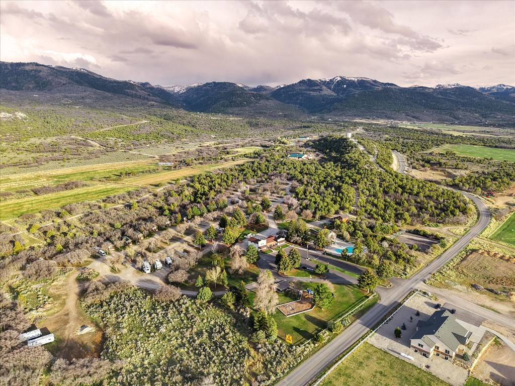
Manti-La Sal KOA Holiday is a year-round, wooded 24-acre campground at 2903 S 1700 E, Mount Pleasant, Utah, run by Katie and Brent Crosby. We sit at about 5,900 feet at the base of the Wasatch Plateau, in the middle of Sanpete County — about an hour from Provo and an hour and a half from Salt Lake City.
Above us is the Arapeen OHV Trail System: more than 350 miles of designated trail by the Forest Service’s count, 600-plus miles once Sanpete County adds the forest roads, topping out at 10,897 feet at High Top. ATVs and UTVs are street legal on Sanpete County roads, so you can ride out of the campground and be at a trailhead in about fifteen minutes without loading a trailer.
In July, when the valley is 85 and Moab is 99, it’s about 70 degrees at 10,000 feet. That’s the whole reason people come.
Fourteen small towns ring us. Somebody in one of them is throwing a festival almost every month of the year.
First: where these mountains actually are
Our name confuses people, so let’s clear it up before anything else.
The Manti-La Sal National Forest is one national forest built from three separate pieces of mountain that don’t touch each other. They’re roughly 200 road miles apart.
They share a name because they were combined administratively in 1950, not because they’re near each other. The Forest Service says so on its own homepage.
We are on the Manti side. Aspen, spruce, alpine meadows, and trout lakes between 8,000 and 11,000 feet, fifteen minutes from town. The La Sal Mountains near Moab are about 140 miles away as the crow flies and roughly four hours by road. If you’re picturing red rock, that’s the other end of the forest.
The mountain directly above us is the Wasatch Plateau — locally, “the Manti.” It’s a broad, high tableland rather than a jagged range: 2,792 square miles, general elevation around 8,800 feet, topping out at South Tent Mountain, 11,263 feet. Skyline Drive runs its spine.
About wildfire
Utah had a hard fire year in 2026 — a record for forested acreage burned statewide. Because our name says “La Sal,” we spent the summer taking calls from people who’d seen a fire map near Moab and assumed it was on top of us. It wasn’t. Those fires were hundreds of miles away.
Here’s the straight version of our own summer. The campground operated normally all season. One fire did burn on our side of the forest: the Black Canyon Fire, lightning-caused, started July 30 on the plateau between Ephraim and Spring City. It reached about 3,264 acres and temporarily closed some forest roads, including portions of Skyline Drive and Spring City Canyon Road. Crews had it largely contained by late August. It never reached the valley, and it never affected operations here.
What that means for you as a traveler: don’t cancel a Sanpete trip because you saw a Utah fire headline. Check the specific place. These are the pages that will tell you the truth on any given day:
Utah Fire Info — the interagency hub for active fires and restrictions
Manti-La Sal National Forest alerts and closures — the authoritative source for road and area closures on our mountain
Manti-La Sal fire page — current restriction stage and fire danger by district
AirNow Fire and Smoke Map — smoke and air quality
Utah campfire restrictions map — state and private land
Or call us at 435-660-4959 and we’ll tell you what we’re actually seeing out the office window.
As of September 2026: the Manti-La Sal is under Stage 1 fire restrictions through October 31. Check the alerts page for current status.
Where we are, and how far everything really is
These are road miles and honest drive times measured from the campground, not from the middle of Mount Pleasant. We’re about four road miles southeast of town, which adds a few minutes to everything heading south. Sanpete’s towns are strung out along US-89 farther apart than they look on a map.
The shape of that table is the point. The mountain starts at the property line. The national parks are there if you want them, but they’re the next trip.
The towns we serve — all fourteen, and what’s open
Sanpete County is a line of small towns along the base of the Wasatch Plateau, most settled in the 1850s and 1860s, most still farming. They each do one thing extremely well.
A standing note on hours: small-town Utah runs on short hours and most places close Sunday. Hours below were current when we checked; call before you drive.
Mount Pleasant — home
The “Hub City” of the county — a nickname it earned around 1900, when it was the largest town in Sanpete. You can provision, eat, refuel, and get most things fixed without leaving town.
Food
Rodger’s Dairy Freeze, 1 N State St, 435-462-2623 — burgers, scones, milkshakes. Mon–Sat 11–9, closed Sunday.
Wheeler’s Drive-In, 124 S State St, 435-462-3501 — the other classic drive-in.
The Coffee Depot, 845 S Hwy 89, 435-462-2667 — espresso, crepes, paninis, smoothies. 7 a.m.–5 p.m. daily.
Mt Pleasant Mercantile, 84 W Main St — a vintage soda fountain and ice cream parlor with gifts. Mon–Thu 3–8, Fri 3–9, Sat 12–9, closed Sunday. The best after-dinner walk in town.
Cavalier Pizza, 1050 S State St #3, 435-462-3388 — salad bar, takeout, online ordering.
La Casa del Fogón, 505 N State St, 435-462-1633 — Mexican grill. Wed–Sat 11–8.
La Gringa, 848 S Hwy 89, 435-462-1540 — Mexican, big portions, serves beer. Mon–Sat 11–8.
Leticia’s el Sabor Latino, 122 W Main St, 435-462-1396 — street tacos and enchiladas. Tue–Fri 11:30–7 only.
Subway, 1050 S State St #4.
Triangle Bar, 96 W Main St.
Groceries, dollar stores, fuel
The supermarket at 1050 S State — full service with a deli, bakery, and pharmacy. Long known as Terrel’s; Ridley’s Family Markets acquired the Terrel’s chain in February 2026 and rebranded that spring, so the sign may say something different than the locals do.
Dollar General, 828 US-89 — 8 a.m.–10 p.m. daily.
Family Dollar, 1085 S Hwy 89.
Sinclair, 115 N State St — diesel, 24-hour fueling, car wash, air, convenience store.
Maverik, 381 S State St — open 24 hours.
State liquor store, 22 W Main St, 435-462-3258 — listed Tue–Sat noon–7, closed Sunday and Monday. Call first; hours on the state system move around. (Utah grocery and convenience stores sell beer up to 5%.)
Hardware, parts, and repair
Horseshoe Mountain Home Center (Do It Best), 1095 S US-89, 435-462-0100 — Mon–Sat 7:30–6, closed Sunday. Lumber, hardware, propane, animal feed, key cutting, chainsaw sharpening, paint matching, Husqvarna dealer, UPS drop-off, and a U-Haul dealer.
O’Reilly Auto Parts, 950 S Hwy 89, 435-274-4245 — Mon–Sat 7:30–9, Sun 9–8. Free battery and code testing, loaner tools, hydraulic hoses built on site.
Bro’s Tire & Automotive, 266 N State St — tires and general repair.
Peak Outdoors RV Service, 15850 N Hwy 89 (between Mount Pleasant and Spring City), 435-462-7325 — Mon–Fri 8–5. RV maintenance, structural repair, plumbing and electrical, tires and axles, winterizing, and a parts counter. The one to know if something on the rig lets go.
Sorensen’s Towing & Recovery, 435-835-1501 — 24/7, serves Mount Pleasant from Ephraim.
Neven’s Thrift Boutique, 152 W Main St — Tue–Fri 10–6, Sat 10–7.
Medical, pharmacy, and services
Intermountain Sanpete Valley Hospital, 1100 S Medical Dr, 435-462-2441 — ER open 24/7. A critical-access hospital in town matters more than you’d think when you’re traveling with grandparents or small kids.
Skyline Pharmacy, 1 W Main St, 435-462-2434 — Mon–Fri 9–7, Sat 9–2. Compounding pharmacy. Second pharmacy inside the supermarket.
Sanpete Veterinary, 1180 Blackhawk Blvd, 435-462-1776 — small and large animal.
Post office, 55 N 100 W — Mon–Fri 9–4:30, Sat 9–12.
Cache Valley Bank, 210 S State St.
Sanpete Shooting Sports, 435-462-5239 — firearms, archery, instruction. Two addresses circulate; call before driving.
Things to do right in town
Basin Drive-In Theatre, 680 N State St, 435-462-2712 — a real drive-in, single screen, about 200 cars, open since 1958 and billed as Utah’s smallest. Digital projection, FM sound, so bring a radio. $7 adult, $5 child and senior. Season runs roughly April through late October.
Mt. Pleasant City Aquatic Center, 106 W Main St, 435-462-2456 — indoor, year-round. Mon–Fri 6–9:30 a.m. and 1:30–9 p.m., Sat 12–9. Family Fun Day is $2 a person on Monday nights. The rainy-day and mid-winter answer.
Mt. Pleasant Public Library, 24 E Main St — the original Carnegie building.
Mount Pleasant Commercial Historic District — Main Street, on the National Register.
Disc golf at City Park — nine holes, free. Reviewers report missing baskets, so treat it as casual.
The history: the Relic Home, the 1861 William Stuart Seeley House on S State Street, is the reported site where the Black Hawk War peace treaty was signed on September 7, 1872. It was listed on the National Register in 1992, and it’s a working museum today.
Wasatch Academy, founded 1875 by Presbyterian minister Duncan McMillan, is Utah’s oldest private boarding school and still operating, with students from more than thirty countries.
Mount Pleasant is also the origin point for the ride described in Part 2: out the campground gate, through town on county roads, up Pleasant Creek Canyon, onto the Skyline.
Fairview — 10 miles north, about 15 minutes
The gateway to UT-31 up Fairview Canyon — the paved, plowed, year-round scenic drive — and to Snowland Ski Area, Gooseberry Reservoir, Benchs Pond, and the whole Energy Loop.
Food
Papas Pizzeria, 245 S State St, 435-427-3689 — four-day fermented dough, and they make fresh donuts daily. Mon–Thu 11–8, Fri–Sat 11–9. The highest-rated restaurant in town.
Corner Station Deli & Co-op, 111 S State, 435-427-5500 — sandwiches, soups, gourmet coffee, smoothies, in a restored 1920s service station, with a co-op of local gifts and antiques inside. Mon–Sat 7 a.m.–9 p.m., Sun 11–4 — the longest hours in the north end of the county.
Home Plate Café, 215 N State St, 435-427-9300 — diner. Omelets, chicken fried steak, house-made pies. Mon–Thu and Sun 7–8, Fri–Sat 7–9.
T-Cee’s Dari Freez, 235 N State St, 435-427-9550 — burgers, fries, shakes. Mon–Sat 11–9.
Jose’s Café, 36 W 400 N, 435-427-3702 — counter-service Mexican inside the Exxon. Carne asada, tortas, birria pizza. Mon–Sat 10–7.
Fuel and services
Mehar’s Market / Exxon, 36 W 400 N, 435-427-5355 — convenience store and fuel.
Chevron / 7-Eleven, 334 N State St.
Cox Automotive & Sports, 255 E Canyon Rd, 435-427-9241 — a Polaris and Husqvarna dealer with a full service department, plus towing. Mon–Fri 9–6, Sat 9–2. If your machine breaks on the Skyline, this is the closest shop that knows it.
Big Pine Sports, 340 N Milburn Rd, 435-427-3338 — powersports dealer.
There’s no grocery store or pharmacy in Fairview; that’s Mount Pleasant, six miles south.
The Fairview Museum of History & Art is the reason a lot of people stop here, and it’s much bigger than its reputation. Details in Part 3.
Spring City — 9 miles south, about 15 minutes
The entire town is a National Register historic district, listed in 1980, with the district boundaries drawn at the city limits and roughly fifty 19th-century structures — four pioneer houses from the 1860s, twenty-four from the 1870s, twenty from the 1880s, plus the rock chapel, stores, firehouse, theater, jail, and school. Utah’s state tourism office calls it one of only two places in the country where the whole town is listed.
Be clear on what that means in practice: almost every one of those buildings is a private home. There is no visitor center, no printed walking-tour map, and nothing reliably open on a walk-in basis. What you get is the streets — and the streets are genuinely worth an hour. Park on Main and walk. The architecture is all visible from public sidewalks, and it’s the most photogenic free hour in the county.
Food and shops
Das Café, 33 N Main St, 435-462-7484 — German-American. Bratwurst, Belgian waffles, sandwiches. Tue–Sat 8–3 only, closed Sunday and Monday. The highest-rated restaurant in the area, and it closes at three, so plan around it.
Roots 89 Grill, 76 S Main St, 435-462-7632 — burgers and ice cream, with a shaded patio. Bison burger, Firebird chicken sandwich, horseradish fry sauce, milkshakes, and their logo branded into the bun. Mon–Thu 11–8, Fri–Sat 11–9.
Spring City Mercantile, 37 N Main — a modern general store and candy shop: artisan lollipops, caramels, chocolate, clothing, art. Tue–Thu 10–6, Fri–Sat 9–7.
Galleries and studios — hours are irregular at all of them, so treat an open door as luck:
Horseshoe Mountain Pottery, 278 S Main St, 435-462-2708 — Joe Bennion’s working wood-fired studio and shop.
Spring City Arts, 150 E Center, 435-462-5299. Weighted toward winter and toward event weekends.
Sophie’s Black Sheep Gallery, Main Street.
Jock Jones Windsor Chairs.
Also here: The Honey Company (raw honey, hive tours by appointment, 801-735-7227) and Spring Farm, a lavender farm on Center Street. Neither has a walk-in storefront.
If you want inside the historic homes, there are exactly two chances a year: Heritage Day on the Saturday of Memorial Day weekend, and Candlelight Christmas on the second Saturday of December. Both are ticketed, both are worth planning a trip around, and both are in the events calendar in Part 3. The rest of the year, Friends of Historic Spring City publishes 3D interior tours online you can scroll through from a picnic table here.
Spring City is also an OHV access point, via Spring City Canyon and Canal Canyon, and the trailhead for two good hikes.
Ephraim — 18 miles south, about 25 minutes
The largest city in the county (5,611 at the 2020 census) and home to Snow College, founded 1888 as the Sanpete Stake Academy and now enrolling roughly 6,000 students across its Ephraim and Richfield campuses. A college that size in a rural county changes the texture of the place: more food, more open late, more to do.
This is your big-box run. Walmart Supercenter, 777 N Main, is open 6 a.m.–11 p.m. daily with a pharmacy, vision center, and auto care. Dollar Tree, 370 N Main. Ace Hardware, 385 S Main, Mon–Sat 7:30–8 — hardware plus sporting goods, hunting licenses, optics, and firearms. IFA Country Store, 460 S Main, Mon–Sat 8–7 — feed, ranch supply, western wear, pet food.
Food
Roots 89 Roadhouse, 350 N Main, 435-283-8889 — coffee, burgers, and BBQ. Pulled pork nachos, brisket grilled cheese. Mon–Thu 7–9, Fri–Sat 7–10, Sun 7–6 — the latest-open sit-down spot in Ephraim and the only one open Sunday.
Solid Rock Cafe, 96 E Center St, 435-283-0178 — espresso, custom bagel sandwiches, seasonal soups.
Harvest Grill, 27 N Main, 435-283-4755 — burgers and salads, elk burger, Saturday steak special. Mon–Sat 11–9.
The Malt Shop, 150 N Main, 435-283-4101 — retro burgers and shakes.
Roy’s Pizza & Pasta, 81 S Main, 435-283-4222 — gluten-free and vegan options.
Snow Dragon Chinese, 413 S Main, 435-283-6868 — open Sunday.
Los Amigos, 3 E 700 S · Jose’s Café, 295 N Main · Za’s & Da’s Pizza, 726 N 50 E.
East Texas Donuts, 26 E 450 S, 435-283-3333 — Mon–Fri 6 a.m.–5:30, Sat 6–4. Apple fritters, cinnamon twists, kolaches. The county’s donut destination, and worth the drive.
Sip It! Soda Shack, 455 S Main — dirty sodas and treats, Mon–Fri 7–9, Sat 8–9.
Fast food: McDonald’s, Wendy’s, Arby’s, Little Caesars, Domino’s, Subway.
Other
Intermountain Ephraim Clinic, 525 N Main, 435-283-4076 — walk-in care and same-day appointments.
SnoCap Lanes, 605 S Main, 435-283-4522 — bowling and a café.
Towne Theater, 21 N Main, and SouthTowne Theater, 680 S Main — two indoor movie houses.
Granary Arts, 86 N Main — contemporary art gallery.
Ephraim Public Library, 30 S Main — Mon–Fri 10–8, Sat 10–2. Free cards if you live in Ephraim, Mount Pleasant, or Manti.
Tires and repair: RJ’s Tire & Automotive, 650 S Main · Ephraim Tire Pros, 450 S 50 E · Walmart Auto Care.
Banks: Zions, Cache Valley, Mountain America.
The Ephraim Utah Temple is brand new, and the timing matters:
Public open house: September 2–19, 2026, Monday–Saturday 9 a.m.–8 p.m., closed Sundays. Free, no reservations, all ages. About a 45-minute self-paced walk-through, wheelchair accessible, no photography inside.
Dedication: Sunday, October 11, 2026.
After the dedication the interior is reserved for members with a recommend, so the open house is the one window when anyone can walk through. It’s Utah’s 27th temple and Sanpete County’s second.
Ephraim is also where you rent a machine, where Ephraim Canyon climbs onto the Arapeen, and where the county’s biggest event — the Scandinavian Heritage Festival — happens every Memorial Day weekend.
Manti — 25 miles south, about 30 minutes
The county seat, settled in November 1849 by about 225 settlers under Isaac Morley — the oldest town in Sanpete County.
The Manti Utah Temple is the defining silhouette of the valley: dedicated 1888, rededicated 1985, and rededicated again April 21, 2024 after a two-year restoration. The interior requires a temple recommend and is not open to visitors — the 2024 open house was the last public access. The grounds and the hilltop view are public, and the best place to take it in is the Pioneer Heritage Center and Gardens across US-89 at 525 North 100 East: a two-and-a-half-acre city park with a reflecting pond, an amphitheater, and interpretive paths, next to the pioneer cemetery. No fee, no posted hours.
Manti has the county’s only proper printed walking tour — a 29-stop PDF from Sanpete County covering the temple, the tabernacle, the courthouse, pioneer cabins through Victorian mansions, and a reconstructed pioneer dugout. Download it before you go. A visitor center and museum operate at Historic Manti City Hall on Main.
Manti is the county’s event town: the Sanpete County Fair, the Christmas Light Parade, the Halloween Festival, the Manti Mountain UTV Runs, and the Ed “Big Daddy” Roth Rat Fink Reunion all happen here. Manti Canyon is a major Arapeen access.
County tourism runs out of Historic City Hall on North Main — the county lists 160 North Main, 435-835-4321.
Gunnison — 40 miles south, about 48 minutes
A farming town, home to the Central Utah Correctional Facility (Utah’s second-largest prison), and the location of Gunnison Reservoir — realistically a carp-dominated warmwater fishery with catfish and panfish, dirt access roads, and water levels that swing hard in dry years. Gunnison throws one of the county’s bigger Fourth of July celebrations over two days, usually including an FMX freestyle motocross show.
Moroni — 13 miles west, about 20 minutes
Turkey country. The Moroni Feed Company dates to 1938; the Norbest brand goes back to the Northwestern Turkey Growers Association formed in 1930, the first turkey marketing cooperative in the United States. Moroni Feed renamed itself Norbest, Inc. in 2014; Pitman Family Farms acquired it in 2018. It has long been the Sanpete Valley’s largest private employer.
The Moroni Opera House, built 1890–91 at 325 W Main, still stands and made the National Register in 1996.
Food: Shalan’s, 192 W Main, 435-436-5200 — breakfast and lunch on paninis and croissants, specialty drinks, soft serve, with a drive-thru. Mon–Sat 7–8. Los Juan Mexican Restaurant, 100 W Main, 435-436-8535. Value Mart, 95 W Main — gas, convenience, small grocery. Conoco, 47 N 400 E — open 24 hours.
The town’s Fourth of July BBQ turkey dinner is famous across central Utah. People drive in for it.
Fountain Green — 20 miles northwest, about 28 minutes
“Wool City,” and once “the Richest Little City Per Capita in the U.S.” — a nod to a sheep heritage that ran around 100,000 head. Lamb Days has been held since August 23, 1930, started by local sheepmen when Depression lamb prices fell to four cents a pound. It runs in July now: pit-cooked lamb by the dozens, mutton bustin’, a parade down State Street. In December the town does the Live Nativity with a hay ride out to the site. The Ft. Green DUP Museum at 10 S State keeps regular hours, Tue and Thu 11–2.
Wales — 16 miles west, about 22 minutes
Site of the first coal mine in Utah. Coal was discovered in 1854 — the Ute leader Tabiona handed Brigham Young “a black rock” at Fort Ephraim — and Welsh miners John Rees and John Price were sent to find the vein in Coal Canyon. Welsh settlers followed and the town took their name. Twelve coke ovens by 1872; a rail branch from Nephi by 1875. Quiet, and historically significant out of all proportion to its size.
Sterling — about 32 miles south, about 40 minutes
Best known as the address of Palisade State Park and the mouth of Six-Mile Canyon, a classic Arapeen access. The lake is man-made: in the 1860s the settler Daniel B. Funk dammed and diverted part of Sixmile Creek to build a resort. Skyline Recreation, 88 N Main, 435-851-2288, rents machines here.
Chester — 13 miles west, about 18 minutes
An unincorporated farming community of about 180 at the SR-132 / SR-117 junction, founded by David Candland as Canal Creek and renamed for Chesterfield, his English hometown. Chester Ponds — six small reservoirs — is the visitor draw. It was the terminus of the San Pete Valley Railway in 1885.
Mayfield — 37 miles south, about 45 minutes
Settled 1871, population 556. The quiet town at the southwestern corner of the valley, and the gateway to Twelvemile Canyon, which carries the Forest Service’s Twelve Mile Loop onto the Arapeen and the trailhead for the easy Birch Creek Trail.
Centerfield — 42 miles south, about 50 minutes
Founded 1869, incorporated 1909. The Gunnison Valley Sugar Company built a 500-ton sugar factory here in 1918, and the William Wrigley Jr. Company bought it in 1920 to supply chewing gum production; it ran until 1966. The town’s earlier nickname was “Skin Town,” from 1880s cowhide tanning.
Fayette — 45 miles southwest, about 52 minutes
Settled April 8, 1861 by families from Springville and originally called Warm Creek, for a warm spring a mile east. Orson Hyde suggested the name Fayette, after Fayette, New York. The farthest south of the towns we regularly serve.
Riding the Arapeen OHV Trail System
This is why a large share of our guests come, and it’s the thing first-timers most underestimate. This section goes deep. Skip ahead to the street-legal ride from camp if you just want to get on the mountain tomorrow morning.
The Arapeen OHV Trail System — named for Chief Arapeen, the Ute leader in Sanpete Valley after Walkara’s death in 1855 — covers the Sanpete Ranger District of the Manti-La Sal National Forest, directly above us.
The numbers:
350-plus miles of designated, maintained trail by the Forest Service’s count
600-plus miles by Sanpete County’s, once forest roads are included
About 5,800 feet in the valley to 10,897 feet at High Top, on the Skyline
Connects south to the Paiute ATV Trail by way of the Gooseberry Trail system, so the network doesn’t end at the county line
You will not run out of trail on a long weekend. You will not run out on a week.
Official sources worth bookmarking:
Manti-La Sal OHV opportunities — the searchable list of every designated route, 122 entries deep
Motor Vehicle Use Maps (MVUMs) — the legally authoritative answer to “can I ride this?”
Manti-La Sal alerts and closures — check this in fire season
Utah ATV Trails — the local trail association, free route PDFs and the deluxe paper map
How the system is numbered and signed
This trips people up on day one, so spend five minutes on it before you’re at a junction arguing about it.
Three numbering systems overlap on the same ground:
Arapeen route numbers — the small numbers on local trail signs and the county map. Skyline Drive is Arapeen Route #1. Six-Mile Canyon is #35. Harmon is #36. North Fork is #38.
Forest Service road numbers — five-digit, on the brown fiberglass posts and the MVUM. Skyline Drive is #50150. Canal Canyon Road is #50339. Six-Mile Canyon Road is #50047.
Forest Service trail numbers — for narrow and non-motorized trails. Canal Canyon Trail is #5058. Grizzly Gulch is #5412. Left Fork Huntington is #5131.
One canyon can carry all three. Manti Canyon is Forest Road 0045 on the map, part of the Manti Loop in Forest Service literature, and the wide-machine access above it is Arapeen Route #34. That’s not a contradiction — it’s three agencies naming the same dirt.
The MVUM is the legal document. Local maps and apps are for planning. If a route’s motorized status matters — and near Canal Canyon and the Patton Trailhead it genuinely does — check the MVUM or call the district.
Skyline Drive: the backbone of everything
Every ride up here eventually touches Skyline Drive, the gravel road running the crest of the Wasatch Plateau. It’s Arapeen Route #1 and Forest Road #50150, and the Forest Service manages it as two state scenic backways:
North Skyline Drive — about 27 miles, US-6 near Tucker south to SR-31 at Fairview Canyon. Suitable for passenger cars when dry. Closed in winter.
South Skyline Drive — about 55 miles, SR-31 south to the Fishlake National Forest boundary. Rougher: native soil, high clearance recommended, typically passable mid-July into September.
Together that’s over 80 miles of ridge, topping out at 10,897 feet at High Top.
What it’s like: open ridge running, mostly above the trees, with the Sanpete Valley falling away 5,000 feet on one side and the Emery County canyon country on the other. Long views, big sky, almost no shade, and weather that arrives fast. In late July the meadows along it are waist-high wildflowers. In late September the aspen pockets below the rim go gold in every direction.
Why this matters for your group: the north half is drivable in a normal car when it’s dry. The people in your party who don’t ride can still get to 10,000 feet, see what everyone’s been talking about, and be back for dinner.
The street-legal ride from camp
Here’s the detail that changes people’s trips, and the one we spend the most time explaining at the front desk.
ATVs and UTVs are street legal in Sanpete County towns, and all Sanpete County roads are open to OHV use.
The exception is US-89 / Main Street. You may cross it. You may not ride along it unless your machine is fully street-legal plated. Keep it to 15 mph in town. The reason this access still exists is that riders haven’t wrecked it — ride like you want it here next year.
What that means in practice:
You ride out of the campground on regular roads and reach the Powerplant Park trailhead in about fifteen minutes. No trailer. No loading up. No hunting for parking at 8 a.m.
Powerplant Park is the staging area at the canyon mouth, 3.5 miles east of Mount Pleasant on 200 South, up Pleasant Creek Canyon. From there, Pleasant Creek Canyon — Forest Route 0037 — climbs all the way to Skyline Drive.
So the morning looks like this: coffee at the picnic table, helmets on, fifteen minutes of easy county road, then you’re climbing. By mid-morning you’re at 10,000 feet. Come back down, hit our ATV wash, and be clean before dinner.
The street-legal information above comes from the local trail association and county tourism material. It reflects long-standing practice, but ordinances can change — if you’re planning a trip around riding through town, call Sanpete County at 435-835-4321, or call us.
Canyon by canyon, and what each one looks like
The Arapeen is essentially a ridge road with a dozen canyons climbing to it. Pick your canyon, pick your day — and they don’t look alike, which is the part nobody tells you.
Forest Route 0037, from Powerplant Park, 3.5 miles east of Mount Pleasant on 200 South, climbing to Skyline Drive.
What you’ll see: a creek-bottom start under scrub oak and willow, then a long climb through Douglas-fir and dense conifer, opening into aspen and meadow as you approach the ridge. Shaded and green most of the way, which makes it the pleasant afternoon option in August when the ridge is baking.
This is the fifteen-minutes-from-camp option and the first leg of the Mount Pleasant Loop. If you only ride one canyon, ride this one, because you can do it before your coffee gets cold.
From 400 South and 500 East in Spring City, Canal Canyon Road #50339 runs to the mouth of Canal Canyon. Above it, Canal Canyon Trail #5058 climbs 6 miles to Skyline Drive, gaining from 6,916 to 10,511 feet — a 3,595-foot climb rated Most Difficult.
What you’ll see: this is the canyon with the biggest personality change on the mountain. The bottom is a shaded creek corridor with big pines. The middle is dry, broken, rocky ground — bare red and gray rock, sparse juniper, the kind of terrain people describe as looking like Mars. Then the top opens into high meadow and aspen. Three landscapes in six miles.
One important caveat: the Forest Service page for Trail #5058 lists its allowed uses as hiking, biking, and horse, while local OHV material treats Canal Canyon as an access route. Check the MVUM for current motorized status before you commit. Either way it’s not a first-day ride, and there’s no water up there.
Canal Canyon also has the best low-effort family payoff in the county — see the hiking section in Part 3.
Ephraim Canyon Road climbs east out of Ephraim, the standard trailered access for the Ephraim-side loops and the Horseshoe Mountain rides.
Branching off it, New Canyon Road is designated trail #42 on the Arapeen map, running from about 6,400 feet to roughly 8,800 feet at New Canyon Reservoir. Two different roads — worth knowing before someone insists Ephraim Canyon “is” #42.
What you’ll see: oakbrush and pinyon-juniper low down, then a long aspen corridor — this is one of the best fall-color canyons in the county — into spruce-fir near the top. You’ll also pass the Great Basin Experimental Range at 8,500 feet, founded in 1912 in an aspen grove. It isn’t a tourist stop, but it’s the reason this canyon matters: overgrazing here in the early 1900s stripped the range so badly that floods carried boulders and topsoil down onto the towns below for decades. The research done in response essentially invented rangeland management as a science. You’re riding through the birthplace of a discipline.
There’s also an Ephraim Canyon Heritage Tour — six interpretive stations from the forest boundary up to the Summit Overlook.
In winter, Ephraim Canyon carries about 9.5 miles of groomed snowmobile trail, among the best in the region.
Forest Road 0045, from East 500 South in Manti. About 10 miles to Skyline Drive, past Yearns Reservoir and Milky Falls. Park at Manti City Park or continue up the canyon.
What you’ll see: a narrow, steep-walled lower canyon with a creek and a waterfall, opening to alpine basin near the top. The falls alone justify the ride.
Width matters here. The Forest Service routes wide machines onto FR #51185 — Arapeen Route #34 — about 2.7 miles up Manti Canyon Road. The Patton Trailhead, at the end of FR #51007, is 50-inch maximum.
This is the access for the Duck Fork rides and the southern half of the system, groomed for snowmobiles in winter as far as Elderberry Flat.
Six-Mile Canyon Road #50047, Arapeen Route #35, starting east of Sterling. In the same zone: Harmon — Arapeen Route #36 — 50-inch maximum, North Fork — Arapeen Route #38, and Route #39, a connecting segment on the Duck Fork loop.
What you’ll see: the driest of the main canyons at the bottom — sage and juniper, open and exposed — climbing into conifer and then onto the high plateau. Good early-season riding because it melts out first.
The southern gateway, carrying the Forest Service’s Twelve Mile Loop. Big limestone walls low down, aspen and meadow up top. Groomed in winter.
Over the ridge on the Ferron district, Reeder Trailhead stages South Reeder Trail #5037 — Arapeen Route #5, 5.3 miles, More Difficult, 50-inch maximum — which links with Reeder Canyon Trail to form a loop.
A full-day objective, not an after-dinner ride. It pairs with the trophy fishing and the bouldering in Part 3.
The official Forest Service loops
Routes with agency-maintained signage and published descriptions:
Published rides, one-day and multi-day
The local trail association publishes free route sheets. These are the ones guests ask about by name:
Day rides
The Mount Pleasant Loop is the hometown ride: up Pleasant Creek Canyon on Forest Route 0037, north on Skyline Drive past Huntington Reservoir, back down Miller Flat Road past Potter’s Pond, running between 8,000 and 10,000 feet for most of its length. Shade, ridge, three reservoirs, and it starts and ends at your site.
The Ephraim–Spring City Loop is what we recommend to mixed groups and first-timers: up Ephraim Canyon, north along Skyline, down Spring City Canyon, back on county roads. “Easy” at these elevations still means a full day and real weather, but it isn’t technical.
Multi-day
That last one is the sleeper. Four days, 220 miles, a different town every night — a legitimate bucket-list ride that starts a fifteen-minute ride from your site.
Every named trail, lake, and landmark you’ll hear at the campfire
Skyline Drive (Arapeen #1 / FR #50150) — the spine. 27 miles north, 55 miles south, 10,897 feet at High Top. North half drivable in a car when dry.
Miller Flat Road (FR 0014) — the scenic connector past Miller Flat Reservoir, Cleveland Reservoir (about 18 miles east of Fairview on UT-31, around 9,000 feet), and Huntington Reservoir. Three reservoirs on one road, and the descent leg of the Mount Pleasant Loop.
Potter’s Pond — a high pond at about 9,000 feet in upper Joe’s Valley, reached by Miller Flat Road. A destination in its own right and a leg of the Skyline / Potter’s Ponds ride.
Joe’s Valley Reservoir — the big lake on the east side of the plateau. Bouldering people fly in for, trophy fishing, and the Reeder-side riding.
Duck Fork Reservoir — the objective of the Patton Trail rides out of Manti.
Yearns Reservoir and Milky Falls — on the Manti Canyon climb.
New Canyon Reservoir — top of trail #42, off Ephraim Canyon.
Gooseberry Reservoir — up Fairview Canyon, above 8,000 feet. Rainbows, tiger trout, and Arctic grayling.
Grassy Lake and Horseshoe Mountain — Horseshoe is the mountain you’re looking at from much of the valley floor; the summit ride out of Ephraim runs about 43 miles.
Heliotrope Mountain, Mount Musinia, and Bald Mountain — named summits along the Skyline corridor. The answer to “what’s that one called?”
South Tent Mountain — 11,263 feet, the highest point on the Wasatch Plateau and the Sanpete County highpoint, reached from Skyline Drive.
Cove Lake, the Soup Bowl, and Pete’s Hole — the classic water and mud stops. If anyone in your group has ridden here before, they’ll bring up at least one.
Emerald, Snow, Blue, and Island Lakes — the Skyline Drive lakes. To be precise: Snow Lake is the genuinely roadside one. Emerald and Blue each sit about a mile down a side road, and Island needs a quarter-mile walk across a meadow.
What you’ll actually see up there
People come back down surprised, so here’s the honest picture.
The landscape stacks by elevation. The valley floor is sagebrush and irrigated alfalfa. The canyon mouths are pinyon-juniper and oakbrush — dry, scrubby, hot in July. Mid-canyon turns to Douglas-fir and mixed conifer. From about 8,000 feet up it’s aspen groves and Engelmann spruce–subalpine fir, which is the signature of this mountain and the reason it looks more like Colorado than most of Utah. Above that, open meadow and wind-scoured rock.
The wildflowers are a real event, not a footnote. The Wasatch Plateau carries a rare community the Forest Service calls Tall Forb — subalpine meadows “dominated solely by large, luxuriant wildflowers” rather than grass, standing waist to chest high. Peak is roughly mid-July through early August at 9,000 to 10,500 feet. Expect lupine, Indian paintbrush, mountain bluebell, columbine, elephant’s head, yarrow, and mule’s ears. If you have anyone in the group who’d rather photograph than ride, aim your trip at the last two weeks of July.
Fall color runs in two waves, which gives you a longer window than most Utah destinations:
So a late-September trip catches gold up top, and an early-October trip catches it at eye level on the drive in.
Wildlife you might actually see:
Elk — the Manti is one of Utah’s major elk units. Dawn and dusk, meadow edges and aspen. Good odds.
Mule deer — everywhere, from valley alfalfa to the plateau.
Wild turkeys get reported in the area.
Moose — rare here, and we’d rather be straight with you than oversell it. Utah transplanted moose to the Manti in the 1970s and the population never really took. A remnant exists. Treat a sighting as a bonus.
And the sheep. This will surprise you if nobody warns you: the Manti Division carries 98 of the forest’s 122 grazing allotments — the great majority of grazing on the whole national forest. In summer you will very likely come around a bend into a band of sheep with a herder and guard dogs, usually Great Pyrenees or Akbash. Those dogs are working animals and they will come toward you.
What to do: slow down, stop if you need to, give the band a wide berth, don’t rev at them, and keep your own dog leashed and close. Expect cattle guards and gates — leave every gate the way you found it. This has been going on up here since the 1870s, and being decent about it is part of the deal.
Machine width: 50-inch and 66-inch
The Arapeen carries both narrow and wide routes, which is why big side-by-sides work here at all — but not everywhere.
Routes with a published 50-inch maximum include Harmon (#36), South Reeder (#5037), and the Patton Trailhead approach. The Forest Service routes wider machines around some of these; the Arapeen Route #34 detour 2.7 miles up Manti Canyon is the clearest example.
You’ll see mileage splits quoted for the 50-inch and wider networks. We’re not going to print numbers we can’t source. Measure your machine, then check the MVUM or the county map for the specific route. A 64-inch machine at the bottom of a 50-inch trail is a wasted morning.
When to ride, and who to call
The high trails are generally snow-free July through mid-October. The trail association’s recommended window is July 1 to October 15.
Skyline Drive is more complicated than a single opening date. The Forest Service lists a May season of use for both backways, but snow routinely holds the high sections and the southern half well into summer, and South Skyline is often only passable mid-July into September. Plan a June trip as a valley and low-canyon trip — then call and find out.
Fall colors: gold on the ridge from mid-September, in the valley into mid-October.
The low-elevation valley trails stay rideable April–May and again October–November, which extends the season considerably on both ends. Shoulder-season riding here is uncrowded and underrated.
For official conditions, closures, and motorized status, call the Sanpete Ranger District: 540 North Main Street, Ephraim, UT 84627 · 435-636-3300 · Monday–Friday, 8:00–12:00 and 1:00–4:30.
And call us at 435-660-4959. The ranger district is the authority and you should treat it that way — but guests roll in off the mountain every afternoon and tell us what they just rode. We often know a road is drifted in or a creek crossing is running high days before it shows up anywhere official. We won’t always have the newest information, and we’ll tell you when we don’t. But it’s a free phone call and we’re happy to take it.
Permits, education, helmets, and the rules
Utah’s OHV rules have changed enough that old advice still circulates. Here’s the current version.
Non-resident OHV permit — $35, valid 12 months from purchase, sold online only at recreation.utah.gov. (ohv.utah.gov now redirects there.)
Education requirement — this is the one people get wrong:
Operators 18 and older, resident or non-resident, need Utah’s free, one-time online OHV education course.
Operators under 18 need a youth OHV education certificate, from a separate youth safety course or an approved hands-on skills course.
Exemptions exist for snowmobiles, farm use, guided tours, and sanctioned events — which is why organized rides are an easy way to bring a first-timer. Do it before you leave home, not in a parking lot on bad cell service.
Helmets — required on public land for riders under 18, and under 21 for street-legal operation.
Street-legal operation — a street-legal ATV must be plated, registered, and insured. The commonly repeated “50 mph roads only” is a speed cap, not a road restriction: under Utah Code 41-6a-1509, an operator may not exceed the lesser of the posted limit or 50 mph. On roads posted above 50 you may still operate but must stay to the extreme right with reflectors or reflective tape front and rear on both sides. No interstates.
In town — 15 mph, and US-89 / Main Street is cross-only unless you’re fully plated.
Maps, machines, and our partners
We sell the deluxe paper Arapeen map in the camp store. Buy it when you check in. It covers all 600-plus miles, it doesn’t run out of battery at 10,500 feet, and it’s the map everybody at the campfire is pointing at. It’s also available from Utah ATV Trails for $9.99 if you’d rather have it before you arrive.
Free digital backups:
Avenza — search “Utah Arapeen OHV Trail System Area.” Published by Sanpete County, free, GPS-enabled, about 121 MB. Download it on our Starlink Wi-Fi before you leave the property — there’s no signal to do it at the trailhead.
Forest Service MVUMs — free GeoPDFs, and the legally authoritative source.
onX Offroad — covers the system, subscription.
Utah UTV Rentals is based in Ephraim, open 9 to 5 daily. Tell us and we’ll set it up.
The part that matters: they deliver to us. Our guests don’t have to own a trailer, tow a trailer, or drive anywhere to pick up a machine. It’s waiting at your site, and from your site you can ride the county roads straight to the Powerplant Park trailhead. That’s the whole no-trailer promise, available even if you showed up in a sedan.
Their fleet runs Can-Am, Polaris, Kawasaki, and Segway side-by-sides — two-seaters up to a six-seat Segway Fugleman Crew, roughly $275 to $400 a day. Every rental includes DOT helmets, eye protection, a first aid kit, paper and digital maps, a full tank, and a pre-ride inspection.
In winter they run tracked machines — Can-Am side-by-sides on Camso tracks, around $500 a day — and through a sister operation they rent Ski-Doo snowmobiles. Same people. That combination is what makes a February trip here work.
Riders must be 18 or older to drive, 25 or older if there are passengers under 18, with a valid license and the Utah OHV education certificate.
Looking for dirt bikes? Ask us at the desk. Our rental partner doesn’t carry them, but other outfitters in the valley do, and we’ll point you to whoever has the right machine available that week.
Lone Pine Rentals is our partner for people who want the mountains but don’t own a rig.
They deliver and set up travel trailers and bunkhouse trailers — a dozen of them, roughly $100 to $140 a night — plus toy haulers and utility trailers, and a street-legal, OHV-registered side-by-side they call the Boreal Rover, which means you can ride from town without a trailer even on a rental.
Our partner offer: book two or more nights with us and get a night free when you rent from Lone Pine. Two ways to do it — book your rig with Lone Pine first and follow their link to us, or call us at 435-660-4959 and we’ll set it up from this end. Mention it when you book; we can’t add it after the fact.
That’s a genuinely good way to try RV camping before you buy one. Somebody else hauls it, levels it, and picks it up.
The ATV wash is right where you need it. Wash the dust off before dinner, not after it dries.
Ice and cold drinks in the camp store — grab a bag on the way out. Bring your own cooler; we’ll fill it.
Firewood, propane refills, and basics in the store too, so you’re not driving into town at 8 p.m.
Hot showers in the shower house. A day on the Skyline puts more dust on you than you expect.
Card-operated laundry on site — worth knowing on a four-day ride, or if the creek crossing went badly.
Free Starlink Wi-Fi campground-wide — fast enough for video calls, and fast enough to pull down a 121 MB trail map.
Sanpete runs a season of organized rides — a winter tracked ride, a June sunset ride with dinner and a bonfire, two Manti Mountain runs, a Skyline circuit, a jamboree in our own town, an autumn color ride, and a fall Jeep tour. They’re the easiest way to see the system without navigating it yourself, and non-residents don’t need the OHV permit for a sanctioned event. Several sell out. They’re all in the events calendar in Part 3.
Everything else to do
Not everyone in the group rides. For a lot of families, the rest of it is the trip.
Palisade State Park — about 40 minutes from camp, near Sterling
If we had to send a family with kids to exactly one place for the day, it’s this one. Official page: stateparks.utah.gov/parks/palisade, park office 435-835-6676.
Palisade is a reservoir with no gas motors — non-motorized craft and electric trolling motors only. That’s the whole point: it’s quiet. Kayaks, paddleboards, and swimmers instead of wake boats.
What’s there:
A sandy swim beach
Stocked rainbow, tiger, and cutthroat trout
Paddle gear for hire — canoes, kayaks, paddleboards, pedal boats. Roughly $20–30 for a canoe, kayak, or paddleboard for two to four hours; $30–40 for a pedal boat; $5–10 for a kid’s kayak
An 18-hole public golf course, par 72, about 6,500 yards, with the 5 Iron Grill. Tee times: 435-835-4653
A flat lake loop walk, roughly two miles
OHV access into Six-Mile Canyon and onto the Arapeen
Ice fishing in winter
Budget for the gate: current day-use fees are $15 per vehicle Monday–Thursday and $20 Friday–Sunday and holidays, up to eight people. Seniors 65+ pay $10. Summer hours 8 a.m.–10 p.m.
The underrated part: the golf course, the swim beach, and an OHV route are all one address. Golfers, swimmers, and riders, one parking lot. Then everybody comes back here, rinses the lake and the sunscreen off in our showers, and eats at the same picnic table.
Fishing — from trophy tiger muskie to a kid’s first trout
An unusual range of water within an hour and a half of camp. Regulations change annually — check the Utah Fishing Guidebook before you fish.
One honest note first: there is no fishing pond in Mount Pleasant. People ask, and we’d rather tell you than have you drive around looking. The water is up the canyons, and it’s worth the twenty-five minutes.
Gooseberry Reservoir — about 30 to 35 minutes from camp, up Fairview Canyon on UT-31. Above 8,000 feet, stocked with rainbow trout, tiger trout, and Arctic grayling. Float tubes, kayaks, and small boats; no motorized ramp. Open roughly late May to mid-October depending on snowpack, with ice fishing when conditions allow. Grayling in Utah is unusual enough to be worth the drive on its own.
Benchs Pond — 15 minutes to Fairview, then 8.5 miles east on UT-31 and 2.2 miles on UT-264. Stocked rainbow trout, and it’s on Utah DWR’s accessible fishing list for Sanpete County. Also called Beaver Dam Reservoir. This is the one we point grandparents and small kids toward. (DWR notes not every listed site has a hard surface meeting ADA standards.)
Palisade State Park Reservoir — about 40 minutes from camp. Stocked rainbow, tiger, and cutthroat trout, no gas motors, easy shoreline access, and everything else a family needs in the same place. The turnkey option.
Lake Hill Community Reservoir — 25 minutes to Ephraim, then 8.1 miles up Ephraim Canyon. A one-acre pond at 8,400 feet, stocked with tiger and rainbow trout. Small, and there’s no drinking water on site, but it’s about the right size for a six-year-old’s first fish.
Joe’s Valley Reservoir — about an hour and fifteen from camp, over the ridge on the east side. The serious-angler destination. Trophy tiger muskie water: Utah’s statewide rule is one fish over 40 inches, everything under 40 goes back. Joe’s Valley also carries a one-trout-over-18-inches limit. The Forest Service lists splake (trophy fish to 16 pounds), tiger trout, and cutthroat.
The Skyline Drive lakes — Snow, Emerald, Blue, and Island. Up on the ridge, so figure the drive up your canyon of choice plus time on Skyline Drive. Snow Lake is right on the road. Emerald and Blue are each about a mile down a spur; Island is a short walk across a meadow.
Cleveland, Huntington, Electric Lake, Miller Flat, Potter’s Pond, Fairview Lakes, and Scofield — the stillwater cluster up Fairview Canyon on UT-31 and along Miller Flat Road, starting about 35 minutes out and spreading north and east from there. A full day of lake-hopping if that’s your thing.
Gunnison Reservoir — about 48 minutes south. Realistically carp-dominated, with catfish and panfish. Dirt roads, poorly marked, big drawdowns in dry years. We mention it because people ask, not because we’d send you.
Yuba State Park — about an hour from camp. Walleye, wipers, northern pike, tiger muskie, perch, catfish, plus sandy beaches. If somebody wants a motorboat and a beach, Yuba is the answer Palisade deliberately isn’t. Check ramp status before towing a boat — Oasis and Painted Rocks have been closed for low water.
Licenses: anyone 12 and up needs a Utah fishing license. The exception is Utah’s Free Fishing Day, one Saturday in early June (June 6 in 2026), when no license is required statewide and all other rules still apply. There’s no fixed formula for the date — check DWR each spring. Live stocking reports: dwrapps.utah.gov.
Rock climbing and bouldering — two areas with international reputations
Central Utah has two climbing areas with international reputations, and both are day-trippable from camp.
Maple Canyon — about 35 minutes from camp, northwest via Moroni and Fountain Green to Freedom. (It reads as “west” on a map; the road goes north first.) This is the cobblestone conglomerate canyon — walls of embedded river cobbles that climb like nothing else, and that draw sport climbers from all over the world.
Over 700 bolted routes, roughly 5.4 through 5.14
$5 per vehicle day-use fee
About 80 ice routes in winter
Joe’s Valley — about an hour and fifteen from camp. One of the premier sandstone bouldering areas anywhere, managed by BLM near Orangeville: 188-plus bouldering sites and nearly ten miles of social trails. Pads, a crash mat, a cooler of ice from our store, and you can spend a whole day on one boulder. Same drive as the trophy fishing and the Reeder-side riding.
Hiking — eleven trails, from five minutes to the county highpoint
Drive times below are from the campground, same as everywhere else on this page.
Easy and family
Canal Canyon creek and bridge, out of Spring City — about 15 minutes from camp, and our most-recommended short walk. About five minutes up the trail there’s a creek and a bridge where kids and dogs play, and a short foot trail leads toward a falls. That’s a whole low-effort afternoon that almost nobody outside the county knows about. Ask at the front desk and we’ll point you to the turn.
Maple Canyon Arch Loop — about 35 minutes from camp. About 2.8 miles with roughly 1,330 feet of gain, or a shorter out-and-back of about 1.5 miles if you just go to the arch and turn around. Dogs welcome. Shaded down in the canyon, exposed up on the ridge. It scales: the short version works for a six-year-old, the full loop works for someone who wants to earn dinner. Watch the climbers on the cobbles on your way out.
Birch Creek Trail, Mayfield — about 45 minutes from camp, then east on Canyon Road 5.5 miles; trailhead on the left. 3.0 miles, Forest Service rating “Easiest.” Pinyon-juniper and oakbrush, from Twelve-Mile Canyon Road to near Town Reservoir. Shared use — expect motorcycles and OHVs under 50 inches. Bring water.
Palisade State Park lake loop — about 40 minutes from camp. A flat two-mile circuit of the reservoir. Pair it with the swim beach.
Academy Mill Reservoir / Pete’s Hole — up on the plateau off the Skyline, so figure your canyon drive plus ridge time. 2.6 miles, about 230 feet of gain, easy and dog friendly. An old roadbed through meadows to a clear reservoir with beaver ponds and good fishing. High-clearance access road that turns slick when wet. Late spring through fall.
Devil’s Kitchen, on the Nebo Loop — about an hour from camp, via Fountain Green and Nephi. About a block long, paved, stroller and wheelchair accessible, with restrooms at the trailhead. Orange and deep-red hoodoos that people call a mini Bryce Canyon. The Nebo Loop closes in winter.
Moderate
The “S” Trail, Ephraim — about 25 minutes from camp. Just under a mile each way and steep the whole way, but wide and impossible to lose, with a bench partway up and a big valley view at the top, at Snow College’s hillside letter. Head up Ephraim Canyon Road to where the pavement ends, turn left down toward the water treatment buildings, and park. Short, and a genuine workout — good for teenagers with energy to burn.
Left Fork of Huntington Creek National Recreation Trail — up Fairview Canyon on UT-31, past Electric Lake, so figure a good deal more than the 15 minutes it takes to reach Fairview. Trail #5131, 6 miles along a trout creek. Fishing rod optional, recommended.
Fish Creek National Recreation Trail — from Fish Creek Campground, off the north end of Skyline Drive. 9.6 miles, rated More Difficult, climbing 1,080 feet to North Skyline Drive. Two bridged crossings, willows along the creek, aspen and conifer on the north-facing slopes, and popular fishing access. Most people hike it downhill from Skyline Drive, or just do the lower two or three miles out-and-back.
Harder
Grizzly Gulch Trail #5412, Spring City — about 20 minutes from camp: 15 to Spring City, then east on 400 South half a mile and Forest Road #51219 about three miles. 7.2 miles, More Difficult, 1,030 feet of climb from 6,916 to 7,946 feet. It connects to Horseshoes Trail #5090 and up to Canal Canyon Trail #5058, so it builds into a much bigger day.
Candland Mountain Trail #398, near Electric Lake on UT-31 — about 35 minutes from camp. 6.3 miles point to point, 2,210 feet of gain, 8,798 to 10,289 feet. Rocks, roots, steep pitches, and views over Millers Flat. Dogs allowed.
Canal Canyon Trail #5058 — about 15 minutes from camp to the Spring City trailhead. The full version: 6 miles, Most Difficult, 3,595 feet of climb from Spring City to Skyline Drive, through pine bottom, bare rock middle, and high meadow top. No water. Connects to Grizzly Gulch #5412, Horseshoe #5090, and Little Horseshoe #5074.
South Tent Mountain — reached from Skyline Drive, so the drive is however long your canyon takes plus time on the ridge. 11,263 feet, the highest point on the Wasatch Plateau and the Sanpete County highpoint. The objective for anyone who collects summits. The access road can be impassably muddy well into summer.
Scenic drives — for the days nobody wants to work for it
UT-31 up Fairview Canyon — 15 minutes from camp to Fairview, then the canyon. Paved and plowed year-round, no seasonal gate, though avalanche danger has closed it briefly in past winters. It climbs toward 10,000 feet and passes Huntington Reservoir, where the Fairview mammoth was found in August 1988. This is the drive for an arrival evening or a departure morning: it puts a sedan at high elevation in half an hour.
The Energy Loop: Huntington/Eccles Canyons National Scenic Byway — starts about ten minutes from your site. Roughly 85 miles of SR-31, SR-264, and SR-96, a National Scenic Byway since 2000. Yellow aspen and dark conifer at 10,000 feet. A half-day loop.
Skyline Drive, north section — reached up Fairview Canyon, so about half an hour to the ridge. Drivable in a passenger car when dry. How the non-riders get to see the top of the mountain everyone’s been talking about all weekend.
The Sanpete Audio Driving Tour — Sanpete County publishes a narrated driving tour from Nephi Canyon down to Gunnison, in two parts of about 40 minutes each. Free, and it turns the drive between towns into the history lesson.
Hunting — the Manti unit
The Manti elk unit covers 2,563 square miles, 74% of it public land, from 5,500 to 11,065 feet. The deer unit is officially “Central Mountains, Manti.” It’s a classic Utah mule deer and elk destination.
We make a practical basecamp, and you have options beyond the rig. Full hookups, a place to hang gear, hot showers, laundry, ice and a freezer run at the camp store, and the ATV wash. If you’d rather not sleep in a tent in late October, we have six deluxe cabins with kitchenettes and private baths and a lodge that sleeps seven — which is how a lot of hunting parties do it once they’ve done one cold morning too many. The cabins and lodge are also the answer for the guy in the group who didn’t bring anything.
Confirmed 2026 general-season dates:
Big-game applications open in late March — the 2026 period opened March 19. That’s the most important sentence in this section. If you’re reading this in the fall and thinking about next year, set a reminder now, and book the site while you’re at it.
Wild turkeys are reported in the area, though Utah’s turkey boundaries don’t use a “Manti” unit name — check the DWR Hunt Planner for the applicable unit.
Hot springs — the free one and the famous one
Meadow Hot Springs, near Fillmore — about an hour and twenty from camp. Three travertine pools around 100°F, free, no facilities, roadside parking and a short half-mile walk. Dog friendly. It sits on private property and access depends on the landowner’s continued goodwill: obey every posted sign, pack everything out, and check current conditions before driving out.
Mystic Hot Springs, 475 E 100 N in Monroe — about an hour and twenty-five from camp. The paid option, with the vintage bathtubs you’ve seen photos of. Day passes book online.
Either way, come back and get a hot shower here. Neither one has much in the way of facilities.
History, museums, and temples — what you can actually go inside
Most guides list the buildings. Here’s the part that matters: which ones you can walk into, when, and how far they are.
The two Sanpete museums with reliably posted regular hours are Fort Ephraim DUP and Ft. Green DUP. Everything else, call ahead. These are small volunteer operations and they change hours without telling anybody, including us. If a door’s locked, it’s not you.
It deserves more than one line. It’s free, it’s fifteen minutes from camp, and it’s the best rainy-afternoon answer in the county — plan about an hour.
The Horizon Building holds the life-size Columbian mammoth replica, cast from a skeleton found in August 1988 during Huntington Dam excavation at about 9,600 feet, thirteen to eighteen miles from Fairview. A backhoe operator hit it. It came out roughly 90% complete — a bull, and at the time the highest-elevation mammoth find in North America. The replica went up here in 1995. The bones weren’t fossilized — they were preserved well enough that researchers could identify the animal’s last meal, and projectile points found with them suggest human contact roughly 10,000 years ago. The originals live at the USU Eastern Prehistoric Museum in Price. Also in this building: rotating regional art, a Black Hawk War display, a significant Clark Bronson bronze collection, geology and shell collections, and exhibits on the region’s turkey industry and Native American culture.
The Heritage Building — a 1900 schoolhouse, two floors, thousands of artifacts — holds more than 100 sculptures by Avard T. Fairbanks, donated by the artist, who had family here, including life-size bronzes. Period rooms recreate the 1800s: a sitting room with a piano, a furnished bedroom, a full kitchen, and an unusual period dentist’s office.
Outside there’s antique machinery, wagons, horse-drawn hearses, and harvesting equipment — hands-on, which is the part kids remember. There’s also a Military Gallery, an Old City Hall, a granary, and a pioneer cabin on the grounds. The museum runs woodworking and painting classes.
Walking Tour of Manti — about 30 minutes from camp. 29 numbered stops, published by Sanpete County. Some buildings are open to the public; the key to the reconstructed pioneer dugout is available at the motel across the street.
Walking Tour of Ephraim — about 25 minutes from camp, also from Sanpete County.
Sanpete Audio Driving Tour — narrated, Nephi Canyon to Gunnison, two parts of about 40 minutes each.
Ephraim Canyon Heritage Tour — 25 minutes to Ephraim, then six interpretive stations from the forest boundary up to the Summit Overlook.
Mormon Pioneer National Heritage Area — regional history, museum index, and the Autio audio app.
Spring City has no printed walking tour, which is genuinely a gap. What it has is streets you can walk freely — about 15 minutes from camp — and 3D interior tours online from Friends of Historic Spring City. Pull those up on our Wi-Fi, then go look at the outsides.
Wasatch Academy, Mount Pleasant, about 8 minutes — founded 1875, Utah’s oldest private boarding school.
The Moroni Opera House, 325 W Main, about 20 minutes — built 1890–91, National Register 1996. Exterior only.
Wales, about 22 minutes — the first coal mine in Utah, coal discovered 1854.
Spring City’s National Register historic district, about 15 minutes — the whole town, listed 1980.
Snow College, Ephraim, about 25 minutes — founded 1888.
The Great Basin Experimental Range, up Ephraim Canyon — founded 1912; the birthplace of rangeland science.
Centerfield, about 50 minutes — the 1918 sugar factory that Wrigley bought in 1920, running until 1966.
The Basin Drive-In, Mount Pleasant, about 8 minutes — open since 1958, April through late October.
You can do most of that in one loop day: Fairview museum in the morning, Spring City on foot at midday, Manti walking tour at golden hour, drive-in after dark.
Winter and the off-season
We’re open year-round, and the months nobody thinks about are quietly the best value in Utah. The sites are open, the rates are gentler, the mountain is empty, and the campground is genuinely quiet.
Snowmobiling — the big one
Utah State Parks grooms two complexes on the mountain above us.
Ephraim / Manti / Mayfield Complex — Ephraim Canyon is about 25 minutes from camp and carries about 9.5 miles groomed, considered some of the best riding in the region; Manti Canyon, about 30 minutes, groomed to Elderberry Flat; plus Twelvemile Canyon out of Mayfield, about 45 minutes.
Scofield / Skyline Drive Complex — the Skyline and Miller Flat country directly above Mount Pleasant, reached up Fairview Canyon in about half an hour.
Don’t have a sled? Our rental partner runs Ski-Doo snowmobiles and tracked side-by-sides out of Ephraim through the winter — same people as the summer UTVs — and they deliver to us. Which means the same no-trailer trip works in February.
Snowland Ski Area — the local story worth watching
Snowland sits 7.8 miles east of Fairview on UT-31, about 25 minutes from camp. A small nonprofit hill — the Snowland Foundation, a 501(c)(3), partnered with Wasatch Academy and Snow College — that reopened January 17, 2026 after 46 years closed. It last ran from 1967 to 1980.
Current status: closed for construction, expected to reopen in December 2026. A brand-new surface lift goes in during fall 2026, along with expanded terrain, more parking, a new lodge, a dedicated tube run, and yurt rentals. Lift tickets stay free through the 2026-27 season; charging begins 2027-28. Its first winter ran free rope-tow Saturdays by online reservation, capped at 80 people a day.
No ski or snowboard rentals on site, and tubing and sledding are prohibited until the dedicated run is finished. Because this is new and moving fast, check snowlandutah.org before you plan a day around it — and call us, because we hear how it’s going.
Ice fishing
Palisade State Park, about 40 minutes, does ice fishing, and Gooseberry Reservoir, about 30 to 35 minutes up Fairview Canyon, freezes when conditions allow. Check the fishing guidebook for ice regulations. Bring your own auger.
Ice climbing
Maple Canyon, about 35 minutes from camp, carries about 80 ice routes in winter, for the small and committed group of people who consider that recreation.
Cross-country skiing and snowshoeing
The groomed snowmobile corridors and the closed sections of Skyline Drive and Fairview Canyon side roads are where people go. UT-31 stays plowed year-round, so you can drive to snow at 9,000 feet in half an hour and be back for lunch.
The February tracked ride, explained
The Arapeen Winter Tracked UTV Ride happens up Ephraim Canyon — about 25 minutes from camp — in late January or February, and it’s the most unusual day on the calendar.
A tracked UTV is a normal side-by-side with the wheels swapped for rubber tracks — like tank treads, one at each corner. It turns a summer machine into something that floats on snow. On this ride, a couple dozen of them run 25 miles of groomed snow up to a 9,900-foot summit, in country that in July is wildflower meadow.
It’s about $10 per UTV, passengers free, sign-in mid-morning about a mile and a half up Ephraim Canyon, back down by mid-afternoon. Bring your own lunch. You don’t need to own a tracked machine — you can rent one, and our partner has them.
Most people have never done anything like it. If you’re looking for a reason to come in February, that’s the reason.
Winter in town
Mt. Pleasant City Aquatic Center, about 8 minutes — indoor pool, open year-round, $2 a person on Monday nights. This is the move when the kids need to burn energy and it’s twenty degrees out.
Two indoor movie theaters in Ephraim, about 25 minutes, plus bowling at SnoCap Lanes.
The Fairview Museum, about 15 minutes, stays open on winter hours — free, warm, and bigger than you’d guess.
Five separate small-town Christmas celebrations in December, all within about forty-five minutes.
And here, in the quiet months
Full hookups run all winter. The shower house is heated, the laundry is on site, the camp store has what you forgot, and the Starlink is the same speed in January as it is in July — which is why we get remote workers who post up here for a month.
The pool is seasonal and closes for the winter. Everything else keeps going.
If a cabin sounds better than a rig in February, six deluxe cabins with kitchenettes and private baths and a lodge that sleeps seven are here, and the pavilion works for a winter group as well as a summer one.
The full year of local events
Everything below happens within about forty-five minutes of camp, every year. Dates shift; the rhythm doesn’t. Check the organiser’s page before you build a trip around a date.
January and February
Arapeen Winter Tracked UTV Ride — late January or February, Ephraim Canyon, about 25 minutes from camp. About $10 per UTV, passengers free. 25 miles of groomed snow to a 9,900-foot summit. Tracked machines required; rentals available. Sign-in about 1.5 miles up the canyon, back by mid-afternoon, bring your own lunch.
April
The Basin Drive-In in Mount Pleasant, about 8 minutes, opens for the season. Low-elevation valley trails come back into shape. This is the start of the cheap, quiet, green stretch.
May — Memorial Day weekend, the county’s biggest
Scandinavian Heritage Festival — Ephraim, about 25 minutes from camp, Friday and Saturday of Memorial Day weekend (May 22–23 in 2026). Free. Running since 1976, drawing close to 20,000 visitors for food, folk dancing, a parade, and Viking contests. The “Little Denmark” weekend, and by a wide margin the largest event on this calendar. If you want a site that weekend, book far ahead.
Spring City Heritage Day — about 15 minutes from camp, the Saturday of Memorial Day weekend, 10 to 4. A tour of historic pioneer homes, the “Art Squared” auction, a framed art sale, a craft market, live music, food trucks. Ticketed — about $15 adult, $10 youth, under 5 free.
This is one of only two days a year you can get inside Spring City’s historic homes. It pairs naturally with the Ephraim festival — do one in the morning, the other in the afternoon.
June — the month we’d fight for
June is not a filler month here. It’s the one where the valley is green, the low canyons are all open, the meadows start blooming, the mountain hasn’t filled up, and you can still get the site you want.
Ed “Big Daddy” Roth Rat Fink Reunion — Manti, about 30 minutes from camp, early June (June 4–6 in 2026). A national Kustom Kulture draw in its twenties now: car show, 5K, live music, pinstriping and airbrush demos, and the Rat Fink Museum. Bigger than its town size suggests, and people come from across the country.
Utah’s Free Fishing Day — one Saturday in early June (June 6 in 2026). No license required statewide. The cheapest possible way to find out whether your kid likes fishing.
Arapeen Sunset UTV Ride — Ephraim, about 25 minutes from camp, late June (June 22 in 2026). About $28 a person. Check-in late afternoon, pizza dinner, ride out at dusk, bonfire around 9:30, back around 10:30. Two moderate route options, roughly 30 miles. This one is a genuinely lovely evening and it sells out.
Also in June: wildflowers begin, Skyline’s south half is usually still closed, and Palisade, Maple Canyon, and every low canyon are at their best. Come in June.
July — the busiest, loudest month
Hub City Days — Mount Pleasant, about 8 minutes from camp — or walk, or ride in. Running roughly the last week of June through July 4 (June 27 – July 4 in 2026). Our hometown celebration: the Freedom Run 1K/5K/10K on the morning of the 4th, the Hub City Rodeo over three nights, a family street dance and color throw, a children’s parade followed by the main parade on the 4th, and fireworks around 10 p.m. You’re staying in the town throwing this party.
Fourth of July, three ways — within about forty-five minutes you have three genuinely different Independence Days:
Manti, about 30 minutes — “Ring Out for Freedom,” a Legion breakfast, a 5K, bike decorating, park games all day, an evening parade, and fireworks at the stadium.
Gunnison, about 48 minutes — two days. July 3 brings food vendors, an FMX freestyle motocross show, an auction, a concert, and fireworks; July 4 brings a 5K, the Legion breakfast, a 9 a.m. Main Street parade, a car show, and a free swim.
Moroni, about 20 minutes — a multi-day celebration built around the BBQ turkey dinner at the Rec Complex, plus a car show, pickleball and volleyball tournaments, the Mammoth Parade, a fireman’s breakfast, a 5K Turkey Trot, a carnival, and fireworks. Moroni has also been known to run an airplane ping-pong-ball drop — a long-standing local tradition that doesn’t appear on every year’s printed schedule, so check the city page if that’s why you’re coming.
Manti Mountain Summer UTV Run — Manti, about 30 minutes from camp, early July (July 7–8 in 2026). A guided two-day ride on the Arapeen with three difficulty levels, staging at Manti City Sports Park. Around $125 a rider, including two breakfasts, two lunches, a catered dinner, and a shirt. The easiest way to see the system for the first time without navigating it yourself.
Lamb Days — Fountain Green, about 28 minutes from camp, mid-July (July 17–18 in 2026). Pit-cooked lamb — thirty-plus lambs — lamb sandwiches, mutton bustin’, a parade down State Street, a fun run, a sawdust dive, softball. Continuously celebrated since 1930.
Fairview Pioneer Days — Fairview, about 15 minutes from camp, about two weeks around July 24 (July 13–26 in 2026). Lace Days at the Fairview Museum, an ATV rodeo, a kids rodeo, two nights of rodeo, a horse parade, the Pioneer Day Parade on July 24, and a demolition derby with fireworks to close.
Spring City Pioneer Day — about 15 minutes from camp, spread across about a week (July 19–27 in 2026): a fireman’s breakfast, a 5K, cornhole, Chalk the Walk, a pioneer baking contest, a town-wide scavenger hunt, and the Main Street parade on July 24 at 10 a.m. Fireworks depend on fire restrictions.
Spring City Bluegrass & Folk Festival — about 15 minutes from camp, late July into early August (July 31 – August 1 in 2026), in Spring City Park.
Also in July: the high country opens, the full Arapeen becomes rideable, and the Tall Forb wildflower meadows peak in the second half of the month.
August — fair season, and the start of hunting
Sanpete County Fair — Manti, about 30 minutes from camp, late August (August 24–29 in 2026), at the Sanpete County Fairpark. RMPRA rodeo two nights, a demolition derby, motocross, the carnival, 4-H and open exhibits, the junior livestock auction, cowboy poetry, a car and tractor show, Miss Sanpete, and the Mammoth Parade down Main Street to close the week. Fairgrounds admission is free. The county’s big agricultural week and one of the most authentically small-town experiences on this list.
Skyline Circuit Ride — a two-day UTV run along Skyline Drive, staging about two miles up Ephraim Canyon, about 25 minutes from camp, late August (August 24–25 in 2026). About $32 per UTV, passengers free. An evening ride the first day, a full day the second. Explicitly paced for couples and riders 50 and up — if you’ve been put off by the idea of chasing a fast group, this is the one.
Moroni End of Summer Bash — about 20 minutes from camp, early August.
General deer archery opens August 15, and elk archery with it.
September — arguably the best month of the year here
Gold on the ridge from mid-month, three organized rides, a plein air festival, and a college homecoming. September is the month we’d pick if we were the guest, and September sites go early.
Spring City Arts Plein Air Festival and Studio Tour — about 15 minutes from camp. Painters work outdoors across the historic district Tuesday through Friday, then the public art show, quick draw, awards, and studio tour fill the closing Saturday, 10 to 4 (September 5 in 2026). One of Utah’s longest-running plein air events. The dates move between late August and mid-September, so check springcityarts.org.
Mt. Pleasant Skyline UTV Weekend — our own town, about 8 minutes from camp, mid-September (September 11–12 in 2026). A guided jamboree showcasing the north end of the Arapeen.
Manti Mountain Fall UTV Run — Manti, about 30 minutes from camp, the following week (September 17–18 in 2026), same format as the summer run, around $125 a rider.
Snow College Homecoming — Ephraim, about 25 minutes from camp, mid-to-late September (September 18–19 in 2026): a Saturday afternoon parade around campus, the “Forever A Badger” tailgate, and football at Terry Foote Stadium.
Arapeen Autumn UTV Ride — late September (September 28 in 2026), timed to the color.
Muzzleloader deer runs September 23 – October 1.
October — color, then costumes
Valley color holds into mid-October. General rifle deer runs October 17–25; elk seasons run October 3–16. The low-elevation valley trails stay rideable through November after the high country closes.
Skyline Fall Jeep Tour — check-in at Lion’s Park Pavilion in Fairview, about 15 minutes from camp, early October (October 2–3 in 2026). About $55 per Jeep, passengers free. Jeeps and street-legal 4x4s only — UTVs go on the Autumn Ride instead. A guided day with a catered lunch, then a self-guided second day. Also paced for riders 50 and up.
Manti Halloween Festival — Manti, about 30 minutes from camp, the Saturday before Halloween, at the city Sports Complex, roughly 5:30 to 8: kids’ games, a pumpkin patch and carving, “Spookers’ Alley,” entertainment, and a trunk-or-treat.
The Basin Drive-In closes for the season around the third week of October.
November — the Christmas season starts the day after Thanksgiving
Mount Pleasant “Lights Up” — about 8 minutes from camp, the town tree lighting, late November.
Manti Christmas Light Parade — Manti, about 30 minutes from camp, the Friday after Thanksgiving. Line-up at 5 p.m. at the red church on 300 S Main; parade at 6 p.m. down Main Street; Santa immediately after in the old Manti High gym — bring letters in stamped, self-addressed envelopes — with food and activities. The county’s Christmas season opens here.
December — five towns, five celebrations
Five separate small-town Christmas events, none of them commercialized, all within about forty-five minutes, and a quiet campground with hookups to come back to.
Ephraim Christmas Celebration and Lights Parade — about 25 minutes from camp, the first Friday of December: tree lighting, light parade, drone show, Santa, Festival of Trees, music, fireworks. Free.
Spring City Candlelight Christmas — about 15 minutes from camp, the second Saturday of December, 4:00 to 7:30 p.m. Candlelit pioneer-home tours, carolers and bluegrass, a miniature art sale, vendor booths. Ticketed, from about $5, sold at the Old School Community Center, 45 S 100 E. This one fills the town, and it’s the other day of the year you can get inside the historic homes. If you do one December event, do this.
Mount Pleasant Electric Light Parade — about 8 minutes from camp, mid-December, with fireworks. Free. Our hometown one.
Fountain Green Live Nativity — about 28 minutes from camp, the weekend before Christmas, roughly 6 to 8 p.m., free, with a hay ride out to the nativity site. Going on close to twenty years.
Manti and Ephraim keep their lights up through the season — the drive between the two towns at night in December is worth doing on its own.
A note on the organized rides
The Sanpete UTV calendar is run by one organizer and it’s about eight events a year — a winter tracked ride, a June sunset ride, two Manti Mountain runs, a two-day Skyline circuit, the Mt. Pleasant jamboree, an autumn color ride, and a fall Jeep tour. They’re inexpensive, several are paced deliberately for older riders and couples, and several sell out before the month they happen in. Registration opens on utvevents.weebly.com and utahatvtrails.org.
If you’re trying to time a trip to one, call us — we’ll tell you what’s still open and hold you a site.
One event you may find in older articles: the Mormon Miracle Pageant in Manti, for decades the county’s largest event, ended permanently after its final run in June 2019. If a travel article sent you here for it, that’s why you can’t find dates.
Sample trips — weekends, weeks, and reunions
Everything above is a menu. Here’s how to order off it. Weekends for people squeezing it in, full weeks for people who can, and a few built around who you’re traveling with rather than what season it is.
Spring — the shoulder-season weekend, April to May
The quiet, cheap, green one. The high country is still under snow; everything low is open and green.
Friday — Arrive. Set up. Walk five minutes up Canal Canyon (15 minutes out) to the creek and bridge, then dinner at Roots 89 Grill in Spring City. Basin Drive-In after dark if it’s open yet.
Saturday — Low-canyon riding out of camp, or the Fairview Museum in the morning (15 minutes, free, mammoth, Fairbanks bronzes) and Spring City on foot at midday. Maple Canyon in the afternoon, 35 minutes out — the Arch Loop is at its greenest, and the climbers are back.
Sunday — UT-31 up Fairview Canyon to snow line and back, coffee at The Corner Station in Fairview, home.
Summer — the classic long weekend for riders
Friday — Arrive, set up, ride the fifteen minutes out to the Powerplant Park trailhead and up Pleasant Creek Canyon for a short evening leg. ATV wash on the way in, then dinner at the site.
Saturday — The Mount Pleasant Loop, about 45 miles: up Pleasant Creek on Forest Route 0037, north on Skyline Drive past Huntington Reservoir, back down Miller Flat Road past Potter’s Pond. Grab ice and cold drinks from the camp store before you go. Wash, shower, pool.
Sunday — The Ephraim–Spring City Loop (53 miles, easy) if you’ve got the legs, or North Skyline Drive by truck with a stop at Snow Lake if you don’t. Laundry while you pack. Drive home in daylight.
Summer — a full week for riders
The week is where this place actually pays off. You can ride a different canyon every day without repeating yourself.
Sunday — Arrive, set up, short evening leg up Pleasant Creek.
Monday — Mount Pleasant Loop (45 miles). The hometown ride, straight from your site.
Tuesday — Trailer or ride south to Ephraim Canyon, 25 minutes. The Horseshoe Mountain Summit ride, about 43 miles. Stop at the Great Basin Experimental Range on the way up. Dinner at Roots 89 Roadhouse in Ephraim on the way home — it’s the one open late.
Wednesday — Off day. Sleep in. Pool, KampK9 for the dog, laundry, and a run to Ephraim for groceries and East Texas Donuts. Afternoon at the Fairview Museum, 15 minutes out, evening at the Basin Drive-In.
Thursday — Manti Canyon, 30 minutes out, to Skyline Drive past Yearns Reservoir and Milky Falls, about 10 miles up. Take the Manti walking tour in the afternoon if the legs are done.
Friday — Skyline / Potter’s Ponds, 55 miles, rated easy. Big country, long views, three reservoirs.
Saturday — Ephraim–Spring City Loop, 53 miles. Last big day. Wash the machine, shower, eat somewhere with a tablecloth.
Sunday — Slow morning, coffee, home.
Serious riders: the Arapeen Trail 4-Day Circuit is 220 miles and a different town every night. Base here on either end of it.
Summer — a week with kids, nobody rides
Sunday — Arrive. Set up. Pool, playground, barrel train, and the basketball court while you get your bearings. Campfire.
Monday — Palisade State Park, 40 minutes out: swim beach, paddle gear, stocked trout off the shore. Budget $15–20 per vehicle. Come back and rinse the lake off in our showers.
Tuesday — Maple Canyon, 35 minutes out. Short out-and-back to the arch with little ones, or the full 2.8-mile Arch Loop with bigger ones. Watch the climbers on the cobbles.
Wednesday — Slow day in camp. Pool, barrel train, KampK9, laundry, and the camp store for ice cream money. Afternoon at the Mt. Pleasant Aquatic Center, 8 minutes out, if it’s raining. Basin Drive-In after dark.
Thursday — Canal Canyon creek and bridge, 15 minutes out, in the morning — let everybody get wet — then the short foot trail toward the falls. Mt Pleasant Mercantile for ice cream at the soda fountain on the way back.
Friday — Fishing day. Benchs Pond up Fairview Canyon for the little ones (accessible, stocked rainbow), or Gooseberry Reservoir, 30 to 35 minutes out, if you want a real lake. Anyone 12 and up needs a license.
Saturday — Spring City on foot in the morning, 15 minutes out, Roots 89 Grill for burgers, Fairview Museum in the afternoon (free, and the mammoth ends every argument about what to do).
Sunday — Pack up, coffee at The Coffee Depot, home.
The adventure week
For people who’d rather come home tired.
Monday — Maple Canyon, 35 minutes out. Sport climbing on cobbles, 700-plus routes, 5.4 to 5.14.
Tuesday — South Tent Mountain, 11,263 feet, the county highpoint, from Skyline Drive.
Wednesday — Joe’s Valley, an hour and fifteen out: bouldering in the morning, trophy tiger muskie in the afternoon. Long day, worth it.
Thursday — Canal Canyon Trail #5058, 15 minutes to the trailhead — six miles and 3,595 feet from Spring City to Skyline Drive. Pine bottom, bare rock middle, meadow top. No water up there; carry it.
Friday — Candland Mountain, 35 minutes out, 6.3 miles and 2,210 feet near Electric Lake — or Grizzly Gulch, about 20 minutes out, linked into the Horseshoe trails for a bigger day.
Saturday — Fish Creek NRT downhill from North Skyline Drive, 9.6 miles, with a rod.
Every one of those ends with the same three things: ATV wash if you took a machine, hot shower, and the laundry.
Fall — the color weekend, mid-September to mid-October
Friday — Arrive during peak color on the ridge. Evening ride up Pleasant Creek Canyon, or North Skyline Drive by truck with the windows down.
Saturday — Whichever organized ride is running — Mt. Pleasant Skyline UTV Weekend (in town), the Manti Mountain Fall UTV Run (30 minutes), or the Arapeen Autumn Ride. Non-riders take Spring City, 15 minutes out, and, if the timing works, the Plein Air studio tour.
Sunday — Maple Canyon Arch Loop, 35 minutes out, with the leaves turning, then home. Or UT-31 for the valley color if the ridge has already gone.
Fall — the hunting week, October
Base camp, not a tent. Full hookups, a place to hang gear, hot showers, laundry, ice and a freezer run at the camp store, and the ATV wash for the machine you’re using to pack out. If a cabin sounds better than a rig at 20 degrees, we have six, plus a lodge that sleeps seven — enough for the whole party under one roof, with a kitchen.
2026 general rifle deer is October 17–25. Elk seasons run October 3–16. Applications open in late March, so book the site when you apply, not after you draw.
Winter — the December weekend
Friday — Ephraim Christmas Celebration and Lights Parade, 25 minutes out: parade, market, drone show, fireworks.
Saturday — Snowmobile day up Ephraim Canyon (9.5 miles groomed, 25 minutes out) or Miller Flat — our rental partner delivers sleds to your site. Then Spring City Candlelight Christmas, 15 minutes out, 4:00 to 7:30 p.m. Buy tickets early; the town fills.
Sunday — Slow morning. Palisade for ice fishing, 40 minutes out, or the Mt. Pleasant Aquatic Center with the kids, then home.
Winter — the February weekend
Friday — Arrive. Quiet campground, heated shower house, Starlink still fast.
Saturday — The Arapeen Winter Tracked UTV Ride up Ephraim Canyon, 25 minutes out: 25 miles of groomed snow to a 9,900-foot summit, about $10 a machine, tracked rentals available. Nothing else on your calendar will look like it.
Sunday — UT-31 to the snow, Fairview Museum on winter hours, home.
Any season — the no-effort weekend of drives, museums and food
Friday — The Coffee Depot in Mount Pleasant, 8 minutes out, then Spring City on foot, 15 minutes out — the historic district, the galleries if they’re open — and dinner at Roots 89 Grill.
Saturday — UT-31 up Fairview Canyon toward 10,000 feet, past Huntington Reservoir where the mammoth came out. Down to the Fairview Museum, 15 minutes from camp (free — mammoth, Fairbanks bronzes, the period dentist’s office). Afternoon on North Skyline Drive in the car. Dinner at Papas Pizzeria in Fairview.
Sunday — Manti, 30 minutes out: the 29-stop walking tour, the temple from the Pioneer Heritage Gardens, and the Sanpete Audio Driving Tour on the way home.
The family reunion — a long weekend for a group
This is what the property was built for, and it’s the trip we help plan most often.
The setup: the covered pavilion seats 40 to 55. Around it you can put six deluxe cabins (kitchenettes, private baths) for the grandparents and anyone who won’t sleep on a mattress they didn’t buy, the lodge that sleeps seven for one family unit, full-hookup RV sites and premium patio sites for whoever tows, and shaded tent spots for the cousins who don’t care. Everybody sleeps on the same 24 acres.
Thursday — Arrivals trickle in. Pavilion dinner — bring it or cook it. Pool, playground, basketball court, barrel train for the little kids, KampK9 for the dogs.
Friday — Split the group. Riders take Pleasant Creek Canyon or a machine delivered to the site. Swimmers and golfers take Palisade, 40 minutes out. Walkers take Spring City, 15 minutes out, and lunch at Roots 89. Everyone reconvenes at the pavilion.
Saturday — The big group day: Maple Canyon in the morning, 35 minutes out (the Arch Loop scales for every age in the family), pavilion barbecue in the afternoon, Basin Drive-In at night in summer, or a fire and a card game if it’s not.
Sunday — Long breakfast, slow goodbyes, laundry before the drive.
Call us at 435-660-4959 before you book a reunion. Mixed groups need a plan — which sites sit near the pavilion, which cabins are next to each other, where to put the tents so the teenagers aren’t next to the grandparents. We do this constantly and we’d rather build it with you than have you guess from a map.
If you want to range farther
Most guests find plenty within half an hour. But if you’ve got a full day:
Yuba State Park — about 1 hour (walleye, pike, perch, beaches)
Joe’s Valley Reservoir — about 1 hr 15 (trophy muskie, bouldering, Reeder-side riding)
Meadow Hot Springs — about 1 hr 20
Mystic Hot Springs, Monroe — about 1 hr 25
Fish Lake — about 1 hr 30
Goblin Valley State Park — about 2 hours
Capitol Reef National Park — about 2 hr 15
Moab and the La Sal Mountains — about 3 hours
Bryce Canyon National Park — about 3 hr 15
Those are long day trips or next-trip destinations. Straight talk: if your plan is Capitol Reef every day, stay closer to Capitol Reef. If your plan is to be in the mountains by 9 a.m. without a two-hour approach, stay here.
Planning notes: weather, elevation, and what to pack
Elevation is what people underestimate. Camp is at about 5,900 feet. Skyline Drive tops out at 10,897 feet. That’s a mile of vertical between your site and the top of the ride, and the weather up there is genuinely different.
The real numbers. Air cools about 3.5°F for every 1,000 feet you climb, so the top of the mountain runs roughly 15 degrees cooler than town:
For comparison, July in Moab averages 99 degrees. July here averages 85 in the valley and about 70 on the mountain. That’s the pitch, and it’s a real number.
What that means in practice: afternoons on the ridge in July are pleasant, not cold — but mornings and evenings up there run in the 40s even in midsummer, and May and September nights approach freezing at elevation. Pack a real layer every month of the year. Every season, somebody rides up in a t-shirt and comes down cold and unhappy.
Also: afternoon thunderstorms are routine on the plateau in July and August monsoon season. They build fast and they’re serious at 10,000 feet. Start early, watch the sky, and be off the high ridge by mid-afternoon.
Season by season:
Before you leave home:
Take Utah’s OHV education course — free and one-time for operators 18 and up; a separate youth certificate is required under 18
Buy the $35 non-resident OHV permit if you need one — good 12 months
Get a fishing license if anyone 12 or older is fishing
If you’re hunting, remember big-game applications open in late March
Download the free Avenza Arapeen map — about 121 MB, so do it on Wi-Fi (ours works)
When you get here: buy the deluxe paper Arapeen map in our camp store, and grab ice on your way out in the morning.
If conditions are in question: call the Sanpete Ranger District, 540 North Main in Ephraim, 435-636-3300, weekdays 8–12 and 1–4:30 — and call us at 435-660-4959. They’re the authority; we often hear it first.
What people forget: a jacket, sunscreen (you’re a mile up), an FM radio for the drive-in, cash for small-town events, and a leash for the dog when you meet a sheep band.
Frequently asked questions
Wait — aren’t you near Moab? No. The Manti-La Sal National Forest is one forest made of three separate pieces of mountain about 200 road miles apart. We’re on the Manti Division — the Wasatch Plateau, central Utah, about an hour and a half from Salt Lake. The La Sal Mountains near Moab are about three hours southeast. Same forest name, different end of the state.
I saw a Utah wildfire map. Are you affected? Check the specific place before you cancel. Utah had a record fire year in 2026, and most of the fires people called us about were hundreds of miles away. The campground operated normally all season. One fire, the Black Canyon Fire, burned about 3,264 acres on the plateau between Ephraim and Spring City starting July 30 and temporarily closed some forest roads; it never reached the valley or affected operations here. Check the Manti-La Sal alerts page, Utah Fire Info and the AirNow smoke map — or call us.
Can I really ride my ATV or UTV straight out of the campground? Yes. ATVs and UTVs are street legal in Sanpete County towns, and all county roads are open to OHV use. You can ride from camp to the Powerplant Park trailhead in about fifteen minutes without a trailer. The exception is US-89 / Main Street — you may cross it, but not ride along it unless your machine is fully street-legal plated. 15 mph in town.
I don’t own a machine. What are my options? Our rental partner delivers to your site. Utah UTV Rentals in Ephraim brings a side-by-side to the campground — two-seaters up to a six-seat crew machine — and you ride from your site to the trailhead. In winter they bring snowmobiles and tracked side-by-sides. Helmets, eye protection, maps, first aid, and a full tank come with it. Looking for dirt bikes? Ask at our desk and we’ll point you to who has them.
I don’t own an RV either. Lone Pine Rentals, based in Nephi, delivers and sets up travel trailers here — free delivery, booked through the page they keep on their website just for our campground. Stay two nights or more with us and rent from them and we’ll give you a free night. Follow their link to us, or call us at 435-660-4959 and we’ll set it up. Mention it at booking — we can’t add it afterward.
How far is Manti-La Sal KOA from Salt Lake City? About 105 miles, roughly an hour and a half. From Provo it’s about 60 miles, an hour.
How far is it to the towns south of you? Farther than most maps make it feel. Spring City 15 minutes, Ephraim 25, Manti 30, Palisade State Park about 40, Gunnison about 48. Fairview is 15 minutes north.
How big is the Arapeen OHV Trail System? The Forest Service counts more than 350 miles of designated trail; Sanpete County counts 600-plus including forest roads. It runs from about 5,800 feet to 10,897 feet and connects south to the Paiute ATV Trail by way of the Gooseberry system.
When does Skyline Drive open? Depends which half. The Forest Service lists a May season of use for both backways, but snow routinely holds the high sections later, and South Skyline is often only passable from mid-July into September. High trails generally run snow-free July through mid-October. Call the Sanpete Ranger District at 435-636-3300, and call us.
Isn’t June too early? No — June is one of the best months here and the easiest one to get the site you want. The valley is green, the low canyons, Palisade and Maple Canyon are all open, the wildflowers start, and the crowds haven’t arrived. What you don’t get in June is the top of South Skyline. Everything else is running.
Can a regular car get up on the mountain? Yes. North Skyline Drive is suitable for passenger cars when dry, and UT-31 up Fairview Canyon is paved and plowed year-round. Non-riders in your group can still get to high country.
What permits do I need to ride? Non-residents need Utah’s $35 non-resident OHV permit, good 12 months. Operators 18 and older need Utah’s free one-time online OHV education course; operators under 18 need a youth OHV education certificate. Street-legal machines must be plated, registered, and insured. Organized rides are exempt from the non-resident permit, which makes them an easy way to bring a first-timer.
Are helmets required? On public land, for riders under 18. For street-legal operation, under 21.
Is there a speed limit for street-legal ATVs? Yes — the lesser of the posted limit or 50 mph. On roads posted above 50 you may still operate, but stay to the far right with reflectors or reflective tape front and rear on both sides. No interstates.
Does my side-by-side fit? Mostly, but not everywhere. Harmon (#36), South Reeder (#5037), and the Patton Trailhead approach are 50-inch maximum, and the Forest Service routes wider machines around some of them. Measure your machine and check the MVUM for your route.
Where do I get a trail map? We sell the deluxe paper Arapeen map in the camp store. Free digital: the Avenza map, the Forest Service MVUMs (the legally authoritative one), and onX Offroad by subscription.
What’s the best trail for a first-timer? The Ephraim–Spring City Loop — 53 miles, rated easy, best July through October. The Mount Pleasant Loop (about 45 miles) starts from our door. Skip Canal Canyon on a first day out; it’s rated Most Difficult and climbs 3,595 feet in six miles.
Will I run into livestock? Very likely. The Manti Division carries 98 of the forest’s 122 grazing allotments — expect bands of sheep with herders and guard dogs, plus cattle on open range. Slow down, give them room, don’t rev, keep your dog leashed and close, and leave every gate the way you found it.
When do the wildflowers peak? Mid-July through early August, at 9,000 to 10,500 feet. The Wasatch Plateau carries rare “Tall Forb” meadows — waist-to-chest-high wildflowers rather than grass. Lupine, paintbrush, bluebell, columbine, mule’s ears.
When is fall color? Two waves. Skyline Drive and the top of Fairview Canyon peak roughly mid-to-late September; the canyon mouths and the valley follow into early-to-mid October. That gives you a two-to-three-week window, not one weekend.
What is there to do if nobody in my group rides? Plenty. Palisade State Park 40 minutes out (swim beach, paddle gear, 18-hole golf, stocked trout), Maple Canyon 35 minutes out (hiking and sport climbing with an international reputation), the Fairview Museum 15 minutes out (free), Spring City’s historic district 15 minutes out, the Manti walking tour 30 minutes out, UT-31 up Fairview Canyon, eleven documented hikes, fishing at Benchs Pond or Gooseberry, and the Basin Drive-In in town, April through October.
Is there fishing right in town? Not in Mount Pleasant — we’d rather tell you than have you drive around. The water is 25 to 40 minutes up the canyons: Gooseberry Reservoir (rainbow, tiger trout, Arctic grayling), Benchs Pond (stocked, accessible), Palisade, and Lake Hill for little kids. Joe’s Valley, an hour and fifteen out, is the trophy water.
Is the campground open in winter? Yes — year-round. Winter means snowmobiling on two groomed complexes, the February tracked UTV ride, ice fishing, ice climbing in Maple Canyon, and five small-town Christmas celebrations. Snowland Ski Area, 25 minutes out, is closed for construction and expected to reopen December 2026 with a new lift and free tickets through the 2026-27 season.
Is the pool open year-round? No — the pool is seasonal. The campground is not. In winter, the Mt. Pleasant City Aquatic Center is indoors and open all year, about eight minutes away.
What’s the biggest event of the year? The Scandinavian Heritage Festival in Ephraim, 25 minutes out, over Memorial Day weekend — free, running since 1976, drawing close to 20,000 people. Book well ahead. For riders, September is the busiest stretch: the Mt. Pleasant Skyline UTV Weekend, the Manti Mountain Fall UTV Run, and the Arapeen Autumn Ride, all during peak color.
Can I visit the new Ephraim temple? The public open house runs September 2–19, 2026, Monday–Saturday 9 to 8, free and no reservations — that’s the window when anyone can walk through. The dedication is October 11, 2026, after which the interior is reserved for members. Ephraim is about 25 minutes from camp.
Can I get inside the historic homes in Spring City? Two days a year: Heritage Day (Saturday of Memorial Day weekend) and Candlelight Christmas (second Saturday of December). Both ticketed. Spring City is about 15 minutes from camp. The rest of the year the streets are free to walk and the architecture is all visible — and 3D interior tours are online.
Can I hunt from the campground? The Manti unit is a classic Utah mule deer and elk destination and we make a comfortable basecamp. 2026 general deer: archery opens August 15, muzzleloader September 23 – October 1, any legal weapon October 17 – 25. Elk: archery opens August 15; spike-bull October 3–15; any-bull October 3–9 and October 10–16. Applications open in late March — book your site then. If you’d rather not sleep in the cold, we have cabins and a lodge.
Is there Wi-Fi? Free Starlink Wi-Fi campground-wide — fast enough for video calls, and fast enough to download a 121 MB trail map before you head up.
Can we bring the dog? Yes, and there’s KampK9, our dog park, on site. Maple Canyon’s Arch Loop welcomes dogs, and the creek and bridge five minutes up Canal Canyon is a favorite for dogs and kids both. Keep them leashed and close around sheep bands on the mountain.
Do you have space for a family reunion or a group? Yes, and this is the thing we’re best at. The covered pavilion seats 40 to 55, with lodging on site for the whole group: six deluxe cabins with kitchenettes and private baths, a lodge that sleeps seven, full-hookup RV sites, premium patio sites, and shaded tent spots. Grandparents in cabins, towers in RV sites, cousins in tents, everybody at the same table.
Call us at 435-660-4959 before you book a group. Mixed groups need a plan — which sites sit closest to the pavilion, which cabins are next to each other, where the tents go, how to stage arrivals across two days. We build these all the time and we’d rather do it with you than have you guess from a site map. Same goes for hunting parties, riding clubs, and family weddings.
Do you take long-term guests? Yes. We keep Extended Stay sites with a two-month minimum. Call for current availability.
What’s actually on the property? Free Starlink Wi-Fi, KampK9 (our dog park), a camp store with basics, firewood, ice, propane refills, and the Arapeen trail map, card-operated laundry, a shower house, a seasonal pool, a playground, a basketball court, a barrel train for the little kids, and the ATV wash. The covered pavilion seats 40 to 55 and is available to rent for reunions and groups. Twenty-four wooded acres to put it all on.
How cold does it get on the mountain in summer? About 15 degrees cooler than town — so roughly 70 in the afternoon at 10,000 feet in July, and 44 overnight. Pack a layer, even in August.
Come see us
Six deluxe cabins with kitchenettes and private baths. A lodge that sleeps seven. Full-hookup RV sites, premium patio sites, and shaded tent spots. Extended Stay sites with a two-month minimum.
Free Starlink Wi-Fi campground-wide. A covered pavilion seating 40 to 55, available to rent for reunions and groups. KampK9, our dog park. A camp store with basics, firewood, ice, propane refills, and the Arapeen trail map. Card laundry, a shower house, a seasonal pool, a playground, a basketball court, a barrel train, and a clubhouse with arcade and billiards — plus the ATV wash waiting at the end of a Skyline Drive day.
Twenty-four wooded acres at 5,900 feet, at 2903 S 1700 E, Mount Pleasant, Utah. An hour from Provo. An hour and a half from Salt Lake. Open year-round.
If you’re planning around a specific event, a specific ride, a specific fish, or a group that needs a plan, call us at 435-660-4959.
Mountains. Made Doable.
See you at the ATV wash.