Guest Adventure Log: Manti Canyon to Skyline
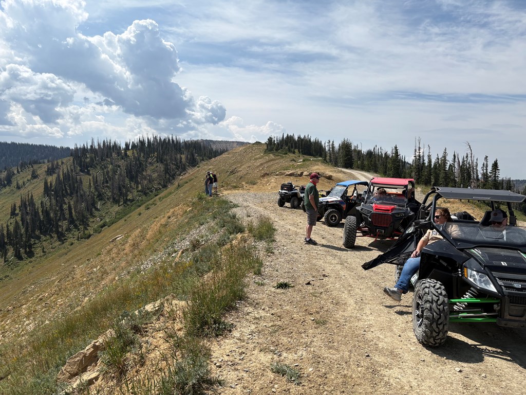
A group of riders used Manti-La Sal KOA as their base camp for a week of exploring the Manti-La Sal National Forest. This is their ride report.
Every fall, a group of friends loads up their UTVs, trailers, and gear and heads to central Utah for their annual trail trip. Every year the same task comes first: finding a hotel or a lodging setup that works. They need somewhere that can sleep a dozen adults, hold five machines, and put up with a group that likes to stay up late playing cards and re-telling the day's ride.
This year they booked five cabins and the lodge at our campground, Manti-La Sal KOA. The cabins gave everyone a bed and their own space, and the lodge became the place they all ended up every night — extra tables set up for meals and card games, everyone under one roof until somebody finally called it.
For the first time in years, nobody complained about the noise! Will this be their first repeat destination? It's been discussed.
Before they headed home, one of the riders wrote up the day's route — Manti Canyon to Skyline, through the downpour, back down North Fork Canyon. Here it is, start to finish. Enjoy!
Editor's note: the author of this log is a family member of the park's ownership team. The route, the conditions and the opinions are entirely his own, from an actual ride.
Heading South from Mt. Pleasant
We had been keeping a close eye on an active forest fire in Black Canyon, about 16 miles southeast of Mt. Pleasant. Several trails in the area had been closed, and before setting out we weren't sure whether smoke, visibility or additional closures might affect our plans. As it turned out, we couldn't have asked for clearer conditions. The skies were blue, visibility was excellent, and during our entire ride we never even noticed the smell of smoke.
Weather would eventually become a major part of our day — just not in the way we expected.
The drive from the KOA to our trailhead took us south through Ephraim and Manti. Ephraim is a fun small college town and home to Snow College. A few miles farther south is Manti, a community rich in pioneer history, where the Manti Utah Temple is impossible to miss sitting high on a grassy hill above Main Street.
Near the south end of Manti's Main Street we turned east on 500 South toward Manti Canyon, and followed the canyon road up to a staging area that easily took our five trucks and trailers. Elevation at the start: about 6,800 feet. Machines unloaded, gear packed, we headed east up the canyon.
The Easy Part
The main Manti Canyon road is well-maintained gravel, rated for RV travel. An easy, relaxing start as we worked deeper into the canyon. That changed when we reached Arapeen Route 32.
Route 32 was narrower, rockier and considerably more technical. Now we were on the kind of trail we had come to ride. We crossed the stream several times and hit rocks, water and some good-sized mud holes.
One hole in particular got everyone's attention. Exceptionally deep, muddy, and stretched all the way across the trail with no obvious right way through it. We stopped and studied it for a while before anyone moved. Each driver ended up picking his own line and working across. It was just difficult enough that getting all five machines through felt like an accomplishment.
Climbing into the High Country
Route 32 kept climbing, and the elevation showed in both the scenery and the vegetation. Within about five miles of the start we were at roughly 8,700 feet. By the 15-mile mark we were above 10,000. Near the top of the canyon we started passing green mountain meadows. Deer, large hawks circling overhead, and — as seems appropriate for Utah mountain country — plenty of cattle grazing along the way.
Eventually the climb brought us to the Skyline area and Jet Fox Reservoir. The reservoir was dry during our visit, but that hardly mattered. Our GPS track topped out at about 10,972 feet, more than 4,000 feet above the staging area. The views seemed to go forever. Standing in the open along Skyline, we had a nearly 360-degree panorama of the high country of the Manti-La Sal National Forest.
It seemed like an ideal place to stop for lunch. Then the skies opened.
So Much for Lunch
This wasn't a sprinkle. It wasn't even one of those afternoon mountain showers where you debate whether the rain jacket is worth the trouble. It started raining buckets.
We pulled out rain gear, climbed back in and drove south along Skyline looking for anywhere sheltered enough to eat. After a couple of miles, nothing. So we turned around and tried north. Same problem. We were in high, exposed country that seemed to be above the tree line. There wasn't much shelter, and the rain wasn't letting up.
Lunch was becoming less important by the minute.
Now, Which Way Is Home?
Skyline was also one of the more confusing navigation points of the ride. Several trails come together up there, and riders have a number of options for heading off in different directions. Under blue skies, that's not a big deal. In a downpour it's different. Paper maps weren't much help — unfolding and reading one in steady mountain rain is an exercise in frustration.
Fortunately one of our machines had GPS. We used it to confirm where we were, pick the right route, and check periodically that we were still on it. We decided on Arapeen Route 3 North, around Elks Knoll and down North Fork Canyon toward Manti.
We also made another decision. Forget lunch. Let's get off the mountain.
A Completely Different Trail
The rain transformed the ride. The top layer of dirt saturated fast. Tires that had been throwing dust in the morning were now grabbing wet soil and launching mud high into the air — onto the machines, and onto us. Pretty soon mud was everywhere. We slipped and slid from one section to the next, and what could have been a miserable ride back to the trailers turned into one of the most entertaining parts of the day.
North Fork Canyon was spectacular. As we dropped down, dramatic white cliffs rose along the right side of the trail while pine-covered slopes climbed on the left. Dark wet rock, green forest, white cliffs — some of the prettiest country we saw all day. We were also suddenly grateful that much of the trail was rocky. The rocks gave the tires something solid to grab while the rain turned everything around them slick.
We kept working down the canyon, checking the GPS now and then to be sure we hadn't wandered onto the wrong trail. Eventually the route connected back to the main Manti Canyon road. After miles of mountain trail in pouring rain, there was something genuinely reassuring about that broad gravel road. From there it was a straight shot down to the trucks.
Lunch for Dinner
The GPS showed about 56 miles for the loop. We'd ridden from roughly 6,800 feet to nearly 11,000 and back. Along the way: stream crossings, rocks, deep mud holes, high meadows, deer and hawks, the Skyline, enormous views, and a genuine high-country downpour. We were also wet, muddy and hungry.
We loaded five extremely dirty machines onto the trailers and headed back to the KOA. Cleaned ourselves up, then took advantage of an amenity that suddenly seemed especially luxurious: the ATV wash. After rinsing an impressive amount of Manti-La Sal mud off the machines, there was only one piece of unfinished business. Lunch. The meal we'd carried around the mountains all afternoon finally became dinner.
Looking Back
The rain didn't ruin the ride. It probably made it. We'd started the day wondering whether a nearby forest fire might interfere with our plans. Instead we got clear skies, beautiful high country and no smoke at all. Then, just when we thought we had the day figured out, the mountains handed us a completely different adventure.
That's one of the things we love about riding Utah's high country. Make a plan. Bring the right gear. Know how to find your way home. Then enjoy whatever the mountain decides to give you.
Ride at a Glance
Route — Manti Canyon to Route 32 to Skyline to Route 3 / North Fork Canyon loop
Area — Manti-La Sal National Forest, Arapeen Trail System
Start — Manti Canyon, east of Manti, Utah
Distance — 55.7 miles, loop
Elevation — start about 6,826 feet, high point about 10,972 feet, total climb more than 4,100 feet
Group — Five trucks and trailers, five UTVs
Terrain — Maintained gravel road, rocky two-track, stream crossings, mud holes, high meadows, Skyline riding
Navigation — Paper maps plus GPS. GPS earned its keep in the rain.
Highlights — Route 32, stream crossings, high meadows, wildlife, Jet Fox Reservoir and Skyline, North Fork Canyon and its white cliffs
Unexpected highlight — A mountain downpour that turned the trip home into a mud fight
Base camp — Manti-La Sal KOA, Mount Pleasant
Ride it again? — Absolutely.
A Few Things We'd Recommend
Mountain conditions change fast. Carry rain gear even when the morning is clear, and don't depend entirely on paper maps. A GPS-enabled trail map was extremely helpful when heavy rain made ours unreadable. A Starlink investment for your ride might be worth it!
Check current fire, road and trail closures before you leave. Conditions in the Manti-La Sal National Forest change, and a route that was open for us may not be open for you. Also note that the Manti-La Sals and the La Sals are different mountain ranges — both are huge, and both sit inside the same national forest. We had routes open all summer despite fires in other regions. Please check local routes before you ride!
Don't be put off by the easy gravel road at the start. Once you turn onto the Arapeen trails, this loop has plenty of rocks, water, mud and mountain to keep it interesting — if you choose. There are also trails wide enough for a jeep.
And if you're staying at the KOA, remember where the ATV wash is. You might need it.
Ready to plan your own Manti-La Sal ride?
Manti-La Sal KOA is in Mount Pleasant, Utah. Open year-round with full-hookup RV sites, tent camping, deluxe cabins and a lodge that sleeps seven.